|
|
|
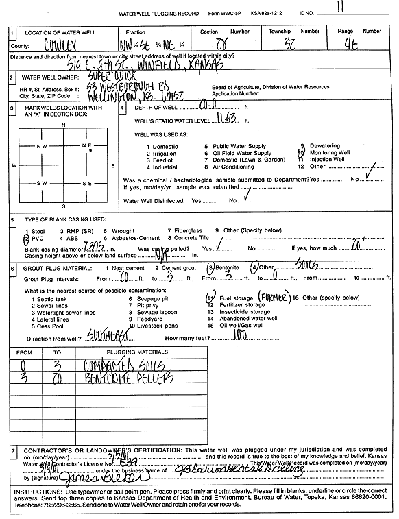
Specific Water Well Detail |
|
|
| Location Info | |||
| Owner: Super Quick | Status: Plugged | ||
| Location: T32S, R4E, Sec. 28, NW SE NE | County: Cowley | ||
| Directions: 519 E 9th St, Winfield | |||
| Latitude: 37.2399826 | Longitude: -96.9903021 | Datum NAD 27 | |
| Latitude: 37.240009 | Longitude: -96.9906162 | Datum NAD 83 | |
| Longitude and latitude calculated by Survey from township-range-section-quarter calls. Only good to within the quarter call accuracy. | |||
| View well on interactive map | |||
| General Info | ||
| Well Depth: 20 ft. | Elevation: ft. | |
| Static Water Level: 11.93 ft. | Est. Yield: gpm. | |
| Comp. Date: 05-Mar-2001 | Well Use: Monitoring well/observation/piezometer | |
| DWR Applic. #: | Other ID: MW 11 | |
| Driller Info | ||
| Driller: JB Environmental Drilling | License #: 539 | |
| Scanned Form | View scan |
| Casing Info | ||
|
Casing Type:
Diam: in. Casing height above land surface: in | ||
| Grout Info | ||
| Grout used: | From: to ft | |
| Source of Possible Contamination | ||
| Source: | ||
| Direction from well: | Distance: ft | |