|
|
|
Specific Water Well Detail |
|
|
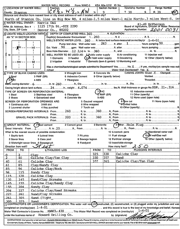
| Location Info | |||
| Owner: Harris Oil and Gas | Status: Constructed | ||
| Location: T30S, R39W, Sec. 9, E2 W2 NW | County: Stanton | ||
| Directions: 4 mi N of Stanton Co line on Big Bow Rd, 1.5 W, 1 N, .3 W, S into site | |||
| Latitude: 37.457311 | Longitude: -101.5948604 | Datum NAD 27 | |
| Latitude: 37.4573317 | Longitude: -101.5953057 | Datum NAD 83 | |
| Longitude and latitude calculated by Survey from township-range-section-quarter calls. Only good to within the quarter call accuracy. | |||
| View well on interactive map | |||
| General Info | ||
| Well Depth: 360 ft. | Elevation: ft. | |
| Static Water Level: 260 ft. | Est. Yield: 90 gpm. | |
| Comp. Date: 04-Jan-2001 | Well Use: Oil Field Water Supply | |
| DWR Applic. #: 20010031 | Other ID: McPherson 1-49 | |
| Links | |
| No Wizard information available. | |
| View info from WIMAS Water Right Data base... | |
| Driller Info | ||
| Driller: Howard Drilling Company AG, LLC | License #: 430 | |
| Scanned Form | View scan |
|
Chemical Sample Submitted?:
Water Well disinfected?: | ||
| Casing Info | ||
| Casing Type:
Casing Joints: |
Diam: in. to ft | |
| Casing height above land surface: in
Casing Weight: lbs/ft Wall thickness or gauge no.: | ||
| Screen and Perforation Info | ||
| Screen Type: | Screen Openings: | |
| Screen-perforated intervals | From: ft to ft | |
| Gravel pack intervals | From: ft to ft | |
| Grout Info | ||
| Grout used: | From: to ft | |
| Source of Possible Contamination | ||
| Source: | ||
| Direction from well: | Distance: ft | |
| Lithologic Log
(Log data entered by KGS.) | ||
| From: 0 ft. to 2 ft. | clay | |
| From: 2 ft. to 40 ft. | caliche clay/tan clay | |
| From: 40 ft. to 61 ft. | caliche clay | |
| From: 61 ft. to 85 ft. | clay/sandy clay | |
| From: 85 ft. to 96 ft. | caliche clay/rock | |
| From: 96 ft. to 115 ft. | sandy clay | |
| From: 115 ft. to 120 ft. | caliche clay | |
| From: 120 ft. to 145 ft. | sand/clay streaks | |
| From: 145 ft. to 155 ft. | caliche clay/sandy clay | |
| From: 155 ft. to 204 ft. | sandy clay | |
| From: 204 ft. to 227 ft. | caliche clay/sand streaks | |
| From: 227 ft. to 261 ft. | sand/clay streaks | |
| From: 261 ft. to 305 ft. | sand (tight) | |
| From: 305 ft. to 325 ft. | sand | |
| From: 325 ft. to 330 ft. | caliche clay | |
| From: 330 ft. to 357 ft. | sand | |
| From: 357 ft. to 365 ft. | caliche clay/tan clay | |