|
|
|
Specific Water Well Detail |
|
|
| Location Info | |||
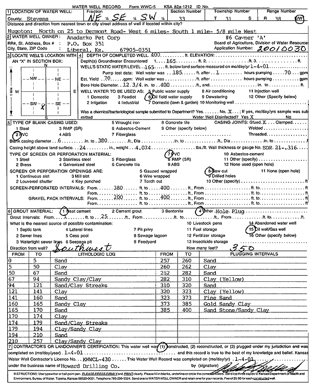
| Owner: Anadarko Petroleum Corp. | Status: Constructed | ||
| Location: T31S, R38W, Sec. 33, NE SE SW | County: Stevens | ||
| Directions: from Hugoton: N on 25 to Dermont Rd, 6 mi W, 1 mi S, .63 mi W | |||
| Latitude: 37.3036263 | Longitude: -101.4575871 | Datum NAD 27 | |
| Latitude: 37.3036497 | Longitude: -101.4580246 | Datum NAD 83 | |
| Longitude and latitude calculated by Survey from township-range-section-quarter calls. Only good to within the quarter call accuracy. | |||
| View well on interactive map | |||
| General Info | ||
| Well Depth: 400 ft. | Elevation: ft. | |
| Static Water Level: 165 ft. | Est. Yield: 70 gpm. | |
| Comp. Date: 04-Jan-2001 | Well Use: Oil Field Water Supply | |
| DWR Applic. #: 20010030 | Other ID: Cavner A-6 | |
| Links | |
| No Wizard information available. | |
| View info from WIMAS Water Right Data base... | |
| Driller Info | ||
| Driller: Howard Drilling Company AG, LLC | License #: 430 | |
| Scanned Form | View scan |
|
Chemical Sample Submitted?:
Water Well disinfected?: | ||
| Casing Info | ||
| Casing Type:
Casing Joints: |
Diam: in. to ft | |
| Casing height above land surface: in
Casing Weight: lbs/ft Wall thickness or gauge no.: | ||
| Screen and Perforation Info | ||
| Screen Type: | Screen Openings: | |
| Screen-perforated intervals | From: ft to ft | |
| Gravel pack intervals | From: ft to ft | |
| Grout Info | ||
| Grout used: | From: to ft | |
| Source of Possible Contamination | ||
| Source: | ||
| Direction from well: | Distance: ft | |
| Lithologic Log
(Log data entered by KGS.) | ||
| From: 0 ft. to 5 ft. | sand | |
| From: 5 ft. to 50 ft. | clay | |
| From: 50 ft. to 67 ft. | sand | |
| From: 67 ft. to 94 ft. | sandy clay/clay | |
| From: 94 ft. to 121 ft. | sand/clay streaks | |
| From: 121 ft. to 141 ft. | clay | |
| From: 141 ft. to 160 ft. | sand | |
| From: 160 ft. to 165 ft. | sandy clay | |
| From: 165 ft. to 170 ft. | sand | |
| From: 170 ft. to 174 ft. | clay | |
| From: 174 ft. to 179 ft. | sand/clay streaks | |
| From: 179 ft. to 194 ft. | clay/sandy clay | |
| From: 194 ft. to 210 ft. | sand | |
| From: 210 ft. to 257 ft. | clay/sandy clay | |
| From: 257 ft. to 260 ft. | sand | |
| From: 260 ft. to 262 ft. | clay | |
| From: 262 ft. to 282 ft. | sand | |
| From: 282 ft. to 310 ft. | clay (yellow) | |
| From: 310 ft. to 320 ft. | sand | |
| From: 320 ft. to 323 ft. | clay (yellow) | |
| From: 323 ft. to 373 ft. | fine sand | |
| From: 373 ft. to 385 ft. | gold sandy clay | |
| From: 385 ft. to 400 ft. | sandstone/sandy clay | |