|
|
|
Specific Water Well Detail |
|
|
| Location Info | |||
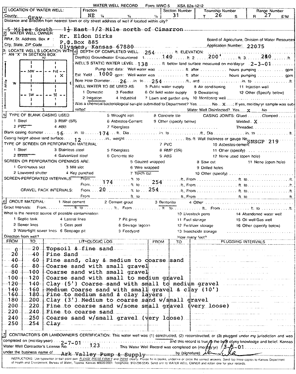
| Owner: Dirks, Eldon | Status: Constructed | ||
| Location: T26S, R27W, Sec. 31, NE | County: Gray | ||
| Directions: from Cimarron: 5 mi S, 1.5 mi E, .5 mi N | |||
| Latitude: 37.7481765 | Longitude: -100.3098924 | Datum NAD 27 | |
| Latitude: 37.7481984 | Longitude: -100.310314 | Datum NAD 83 | |
| Longitude and latitude calculated by Survey from township-range-section-quarter calls. Only good to within the quarter call accuracy. | |||
| View well on interactive map | |||
| General Info | ||
| Well Depth: 254 ft. | Elevation: ft. | |
| Static Water Level: 138 ft. | Est. Yield: 1000 gpm. | |
| Comp. Date: 07-Feb-2001 | Well Use: Irrigation | |
| DWR Applic. #: 22075 | Other ID: | |
| Links | |
| No Wizard information available. | |
| View info from WIMAS Water Right Data base... | |
| Driller Info | ||
| Driller: Ark Valley Pump and Supply | License #: 123 | |
| Scanned Form | View scan |
|
Chemical Sample Submitted?:
Water Well disinfected?: | ||
| Casing Info | ||
| Casing Type:
Casing Joints: |
Diam: in. to ft | |
| Casing height above land surface: in
Casing Weight: lbs/ft Wall thickness or gauge no.: | ||
| Screen and Perforation Info | ||
| Screen Type: | Screen Openings: | |
| Screen-perforated intervals | From: ft to ft | |
| Gravel pack intervals | From: ft to ft | |
| Grout Info | ||
| Grout used: | From: to ft | |
| Source of Possible Contamination | ||
| Source: | ||
| Direction from well: | Distance: ft | |
| Lithologic Log
(Log data entered by KGS.) | ||
| From: 0 ft. to 20 ft. | Topsoil and fine sand | |
| From: 20 ft. to 40 ft. | Fine Sand | |
| From: 40 ft. to 60 ft. | Fine sand, clay and medium to coarse sand | |
| From: 60 ft. to 80 ft. | Coarse sand with small gravel | |
| From: 80 ft. to 100 ft. | Coarse sand with small gravel | |
| From: 100 ft. to 120 ft. | Coarse sand with small to medium gravel | |
| From: 120 ft. to 140 ft. | Clay (5 feet) Coarse sand with small to medium gravel | |
| From: 140 ft. to 160 ft. | Medium Coarse sand with small gravel and clay (10 feet) | |
| From: 160 ft. to 180 ft. | Fine to medium sand and clay layers | |
| From: 180 ft. to 200 ft. | Clay (3 feet) Medium to coarse sand with small gravel | |
| From: 200 ft. to 220 ft. | Fine to coarse sand with some small gravel (very loose) | |
| From: 220 ft. to 240 ft. | Fine to coarse sand | |
| From: 240 ft. to 250 ft. | Coarse sand with small gravel (very loose) | |
| From: 250 ft. to 254 ft. | Clay | |