|
|
|
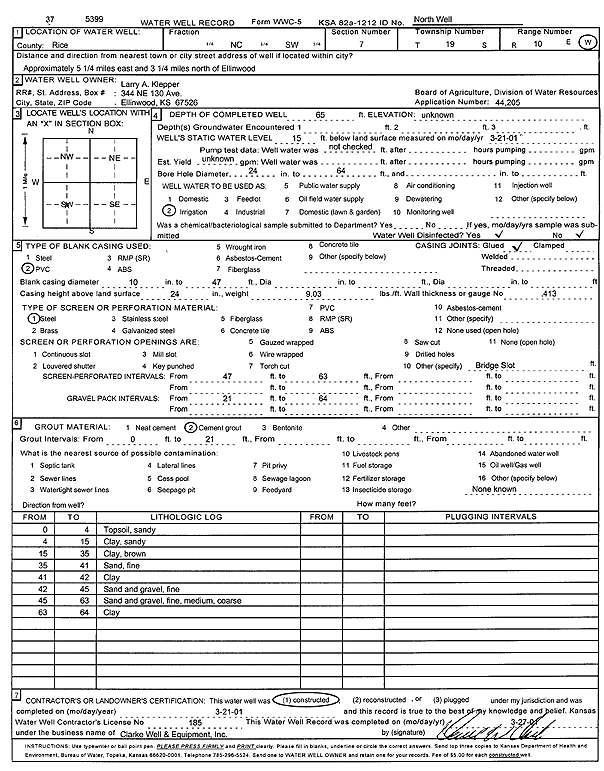
Specific Water Well Detail |
|
|
| Location Info | |||
| Owner: Klepper, Larry A. | Status: Constructed | ||
| Location: T19S, R10W, Sec. 7, C SW | County: Rice | ||
| Directions: from Ellinwood: 5.25 mi E, 3.25 mi N | |||
| Latitude: 38.4092532 | Longitude: -98.4756209 | Datum NAD 27 | |
| Latitude: 38.4092646 | Longitude: -98.4759707 | Datum NAD 83 | |
| Longitude and latitude calculated by Survey from township-range-section-quarter calls. Only good to within the quarter call accuracy. | |||
| View well on interactive map | |||
| General Info | ||
| Well Depth: 65 ft. | Elevation: ft. | |
| Static Water Level: 15 ft. | Est. Yield: gpm. | |
| Comp. Date: 21-Mar-2001 | Well Use: Irrigation | |
| DWR Applic. #: 44205 | Other ID: North well | |
| Links | |
| No Wizard information available. | |
| View info from WIMAS Water Right Data base... | |
| Driller Info | ||
| Driller: Clarke Well and Equipment, Inc. | License #: 185 | |
| Scanned Form | View scan |
|
Chemical Sample Submitted?:
Water Well disinfected?: | ||
| Casing Info | ||
| Casing Type:
Casing Joints: |
Diam: in. to ft | |
| Casing height above land surface: in
Casing Weight: lbs/ft Wall thickness or gauge no.: | ||
| Screen and Perforation Info | ||
| Screen Type: | Screen Openings: | |
| Screen-perforated intervals | From: ft to ft | |
| Gravel pack intervals | From: ft to ft | |
| Grout Info | ||
| Grout used: | From: to ft | |
| Source of Possible Contamination | ||
| Source: | ||
| Direction from well: | Distance: ft | |
| Lithologic Log
(Log data entered by KGS.) | ||
| From: 0 ft. to 4 ft. | sandy top soil | |
| From: 4 ft. to 15 ft. | sandy clay | |
| From: 15 ft. to 35 ft. | clay, brown | |
| From: 35 ft. to 41 ft. | fine sand | |
| From: 41 ft. to 42 ft. | clay | |
| From: 42 ft. to 45 ft. | fine sand and gravel | |
| From: 45 ft. to 63 ft. | sand and gravel; fine, medium, coarse | |
| From: 63 ft. to 64 ft. | clay | |