|
|
|
Specific Water Well Detail |
|
|
| Location Info | |||
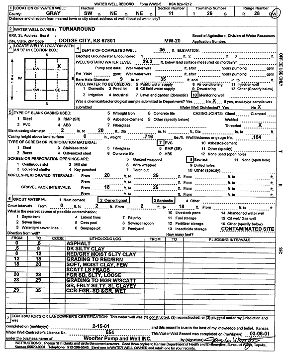
| Owner: Turnaround | Status: Constructed | ||
| Location: T26S, R28W, Sec. 11, SW NE NE | County: Gray | ||
| Directions: | |||
| Latitude: 37.8073398 | Longitude: -100.3452864 | Datum NAD 27 | |
| Latitude: 37.8073613 | Longitude: -100.3457089 | Datum NAD 83 | |
| Longitude and latitude calculated by Survey from township-range-section-quarter calls. Only good to within the quarter call accuracy. | |||
| View well on interactive map | |||
| General Info | ||
| Well Depth: 35 ft. | Elevation: ft. | |
| Static Water Level: 29.3 ft. | Est. Yield: gpm. | |
| Comp. Date: 15-Feb-2001 | Well Use: Monitoring well/observation/piezometer | |
| DWR Applic. #: | Other ID: MW 20 | |
| Driller Info | ||
| Driller: Jay C. Woofter Pump & Well, Inc. | License #: 554 | |
| Scanned Form | View scan |
|
Chemical Sample Submitted?:
Water Well disinfected?: | ||
| Casing Info | ||
| Casing Type:
Casing Joints: |
Diam: in. to ft | |
| Casing height above land surface: in
Casing Weight: lbs/ft Wall thickness or gauge no.: | ||
| Screen and Perforation Info | ||
| Screen Type: | Screen Openings: | |
| Screen-perforated intervals | From: ft to ft | |
| Gravel pack intervals | From: ft to ft | |
| Grout Info | ||
| Grout used: | From: to ft | |
| Source of Possible Contamination | ||
| Source: | ||
| Direction from well: | Distance: ft | |
| Lithologic Log
(Log data entered by KGS.) | ||
| From: 0 ft. to .5 ft. | asphalt | |
| From: .5 ft. to 8 ft. | dark silty clay | |
| From: 8 ft. to 12 ft. | red-gray silty clay, moist | |
| From: 12 ft. to 18 ft. | moist silty clay grading to red-brown | |
| From: 18 ft. to 20 ft. | soft, moist clay, few scattered limestone fragments | |
| From: 20 ft. to 28 ft. | fine sand, silty, loose | |
| From: 28 ft. to 29 ft. | fine sand grading to medium with scattered gravel, fairly silty, slightly clayey | |
| From: 29 ft. to 35 ft. | coarse-fine sand and gravel, wet | |