|
|
|
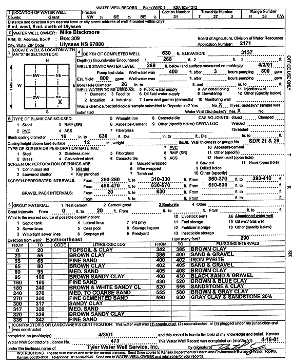
Specific Water Well Detail |
|
|
| Location Info | |||
| Owner: Mike Blackmore | Status: Constructed | ||
| Location: T27S, R38W, Sec. 31, NW SE SE | County: Grant | ||
| Directions: from Ulysses, 8 mi W and 5 mi N | |||
| Latitude: 37.6520398 | Longitude: -101.5115198 | Datum NAD 27 | |
| Latitude: 37.652057 | Longitude: -101.5119677 | Datum NAD 83 | |
| Longitude and latitude calculated by Survey from township-range-section-quarter calls. Only good to within the quarter call accuracy. | |||
| View well on interactive map | |||
| General Info | ||
| Well Depth: 630 ft. | Elevation: 3137 ft. | |
| Static Water Level: 268 ft. | Est. Yield: gpm. | |
| Comp. Date: 03-Apr-2001 | Well Use: Irrigation | |
| DWR Applic. #: 2171 | Other ID: | |
| Links | |
| No Wizard information available. | |
| View info from WIMAS Water Right Data base... | |
| Driller Info | ||
| Driller: Destal Tyler Water Well Service | License #: 473 | |
| Scanned Form | View scan |
|
Chemical Sample Submitted?:
Water Well disinfected?: | ||
| Casing Info | ||
| Casing Type:
Casing Joints: |
Diam: in. to ft | |
| Casing height above land surface: in
Casing Weight: lbs/ft Wall thickness or gauge no.: | ||
| Screen and Perforation Info | ||
| Screen Type: | Screen Openings: | |
| Screen-perforated intervals | From: ft to ft | |
| Gravel pack intervals | From: ft to ft | |
| Grout Info | ||
| Grout used: | From: to ft | |
| Source of Possible Contamination | ||
| Source: | ||
| Direction from well: | Distance: ft | |
| Lithologic Log
(Log data entered by KGS.) | ||
| From: 0 ft. to 20 ft. | TOPSOIL and CLAY | |
| From: 20 ft. to 55 ft. | BROWN CLAY | |
| From: 55 ft. to 65 ft. | FINE SAND | |
| From: 65 ft. to 80 ft. | BROWN CLAY | |
| From: 80 ft. to 95 ft. | MED. SAND | |
| From: 95 ft. to 160 ft. | BROWN SANDY CLAY | |
| From: 160 ft. to 180 ft. | FINE SAND | |
| From: 180 ft. to 240 ft. | BROWN and WHITE SANDY CL | |
| From: 240 ft. to 270 ft. | MED. TO COARSE SAND | |
| From: 270 ft. to 300 ft. | FINE CEMENTED SAND | |
| From: 300 ft. to 317 ft. | SANDY CLAY | |
| From: 317 ft. to 320 ft. | MED. SAND | |
| From: 320 ft. to 336 ft. | BROWN SANDY CLAY | |
| From: 336 ft. to 342 ft. | FINE SAND | |
| From: 342 ft. to 385 ft. | BROWN CLAY | |
| From: 385 ft. to 400 ft. | SAND and GRAVEL | |
| From: 400 ft. to 402 ft. | IRON PYRITE | |
| From: 402 ft. to 405 ft. | SAND and GRAVEL | |
| From: 405 ft. to 408 ft. | BROWN CLAY | |
| From: 408 ft. to 430 ft. | BLACK SAND and GRAVEL | |
| From: 430 ft. to 520 ft. | BROWN and BLUE CLAY | |
| From: 520 ft. to 555 ft. | SANDSTONE and CLAY | |
| From: 555 ft. to 580 ft. | BROWN and GRAY CLAY | |
| From: 580 ft. to 630 ft. | GRAY CLAY and SANDSTONE 30% | |