|
|
|
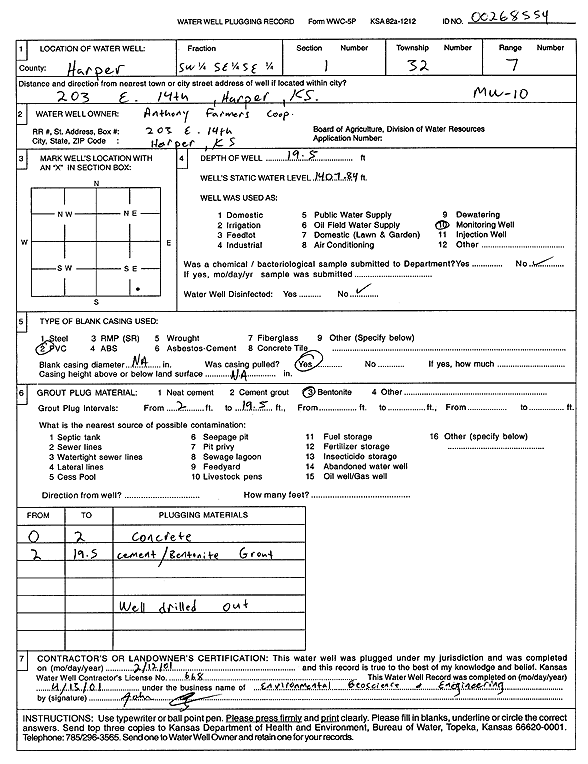
Specific Water Well Detail |
|
|
| Location Info | |||
| Owner: Anthony Farmers Coop | Status: Plugged | ||
| Location: T32S, R7W, Sec. 1, SW SE SE | County: Harper | ||
| Directions: 203 E 14th, Harper | |||
| Latitude: 37.2839579 | Longitude: -98.0244639 | Datum NAD 27 | |
| Latitude: 37.2839775 | Longitude: -98.0248029 | Datum NAD 83 | |
| Longitude and latitude calculated by Survey from township-range-section-quarter calls. Only good to within the quarter call accuracy. | |||
| View well on interactive map | |||
| General Info | ||
| Well Depth: 19.5 ft. | Elevation: ft. | |
| Static Water Level: ft. | Est. Yield: gpm. | |
| Comp. Date: 12-Feb-2001 | Well Use: Monitoring well/observation/piezometer | |
| DWR Applic. #: 00268554 | Other ID: MW 10 | |
| Driller Info | ||
| Driller: Environmental Geosciences and Engineering | License #: 668 | |
| Scanned Form | View scan |
| Casing Info | ||
|
Casing Type:
Diam: in. Casing height above land surface: in | ||
| Grout Info | ||
| Grout used: | From: to ft | |
| Source of Possible Contamination | ||
| Source: | ||
| Direction from well: | Distance: ft | |