|
|
|
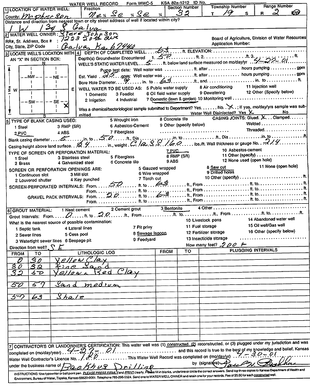
Specific Water Well Detail |
|
|
| Location Info | |||
| Owner: Johnson, Steve | Status: Constructed | ||
| Location: T19S, R2W, Sec. 32, NE SE SE | County: McPherson | ||
| Directions: from Galva: 1 mi W, 1.75 mi S | |||
| Latitude: 38.3505536 | Longitude: -97.5565707 | Datum NAD 27 | |
| Latitude: 38.3505617 | Longitude: -97.5568873 | Datum NAD 83 | |
| Longitude and latitude calculated by Survey from township-range-section-quarter calls. Only good to within the quarter call accuracy. | |||
| View well on interactive map | |||
| General Info | ||
| Well Depth: 63 ft. | Elevation: ft. | |
| Static Water Level: 5 ft. | Est. Yield: 25 gpm. | |
| Comp. Date: 27-Apr-2001 | Well Use: Domestic, Lawn and Garden | |
| DWR Applic. #: | Other ID: | |
| Driller Info | ||
| Driller: Paul H. Backhus Drilling | License #: 180 | |
| Scanned Form | View scan |
|
Chemical Sample Submitted?:
Water Well disinfected?: | ||
| Casing Info | ||
| Casing Type:
Casing Joints: |
Diam: in. to ft | |
| Casing height above land surface: in
Casing Weight: lbs/ft Wall thickness or gauge no.: | ||
| Screen and Perforation Info | ||
| Screen Type: | Screen Openings: | |
| Screen-perforated intervals | From: ft to ft | |
| Gravel pack intervals | From: ft to ft | |
| Grout Info | ||
| Grout used: | From: to ft | |
| Source of Possible Contamination | ||
| Source: | ||
| Direction from well: | Distance: ft | |
| Lithologic Log
(Log data entered by KGS.) | ||
| From: 0 ft. to 30 ft. | yellow clay | |
| From: 30 ft. to 32 ft. | fine sand | |
| From: 32 ft. to 50 ft. | yellow and red clay | |
| From: 50 ft. to 57 ft. | sand, medium | |
| From: 57 ft. to 63 ft. | shale | |