|
|
|
Specific Water Well Detail |
|
|
| Location Info | |||
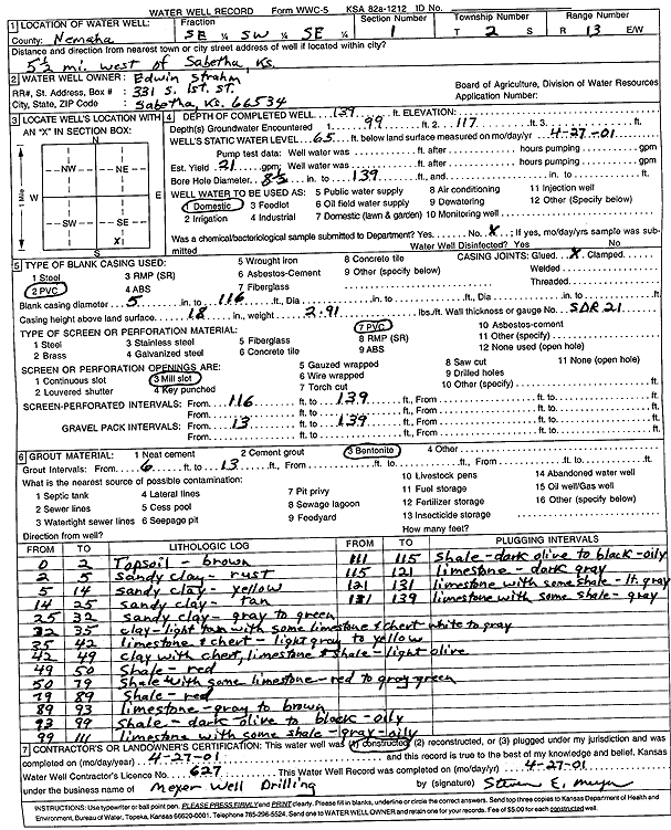
| Owner: Strahm, Edwin | Status: Constructed | ||
| Location: T2S, R13E, Sec. 1, SE SW SE | County: Nemaha | ||
| Directions: from Sabetha, 5.5 mi W | |||
| Latitude: 39.9001773 | Longitude: -95.9074223 | Datum NAD 27 | |
| Latitude: 39.9001766 | Longitude: -95.9076943 | Datum NAD 83 | |
| Longitude and latitude calculated by Survey from township-range-section-quarter calls. Only good to within the quarter call accuracy. | |||
| View well on interactive map | |||
| General Info | ||
| Well Depth: 139 ft. | Elevation: ft. | |
| Static Water Level: 65 ft. | Est. Yield: 21 gpm. | |
| Comp. Date: 27-Apr-2001 | Well Use: Domestic | |
| DWR Applic. #: | Other ID: | |
| Driller Info | ||
| Driller: Meyer Well Drilling | License #: 627 | |
| Scanned Form | View scan |
|
Chemical Sample Submitted?:
Water Well disinfected?: | ||
| Casing Info | ||
| Casing Type:
Casing Joints: |
Diam: in. to ft | |
| Casing height above land surface: in
Casing Weight: lbs/ft Wall thickness or gauge no.: | ||
| Screen and Perforation Info | ||
| Screen Type: | Screen Openings: | |
| Screen-perforated intervals | From: ft to ft | |
| Gravel pack intervals | From: ft to ft | |
| Grout Info | ||
| Grout used: | From: to ft | |
| Source of Possible Contamination | ||
| Source: | ||
| Direction from well: | Distance: ft | |
| Lithologic Log
(Log data entered by KGS.) | ||
| From: 0 ft. to 2 ft. | Topsoil, brown | |
| From: 2 ft. to 5 ft. | Sandy clay, rust | |
| From: 5 ft. to 14 ft. | Sandy clay, yellow | |
| From: 14 ft. to 25 ft. | Sandy clay, tan | |
| From: 25 ft. to 32 ft. | Sandy clay, gray to green | |
| From: 32 ft. to 35 ft. | Clay, light tan, with some limestone and chert, white to gray | |
| From: 35 ft. to 42 ft. | Limestone and chert, light gray to yellow | |
| From: 42 ft. to 49 ft. | Clay with chert, limestone, and shale, light olive | |
| From: 49 ft. to 50 ft. | Shale, red | |
| From: 50 ft. to 79 ft. | Shale with some limestone, red to gray green | |
| From: 79 ft. to 89 ft. | Shale, red | |
| From: 89 ft. to 93 ft. | Limestone, gray to brown | |
| From: 93 ft. to 99 ft. | Shale, dark olive to black, oily | |
| From: 99 ft. to 111 ft. | Limestone with some shale, gray, oily | |
| From: 111 ft. to 115 ft. | Shale, dark olive to black, oily | |
| From: 115 ft. to 121 ft. | Limestone, dark gray | |
| From: 121 ft. to 131 ft. | Limestone with some shale, light gray | |
| From: 131 ft. to 139 ft. | Limestone with some shale, gray | |