|
|
|
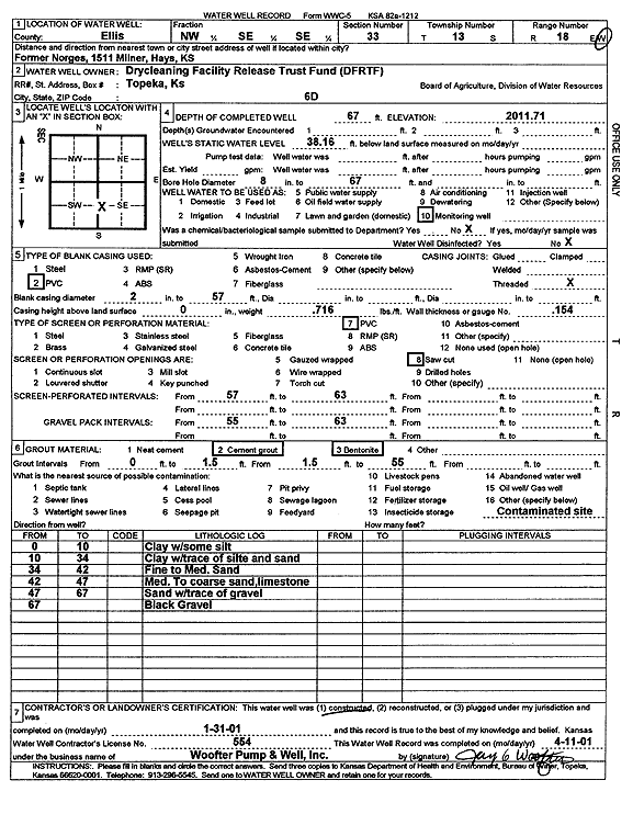
Specific Water Well Detail |
|
|
| Location Info | |||
| Owner: Drycleaning Facility Release Trust Fund | Status: Constructed | ||
| Location: T13S, R18W, Sec. 33, NW SE SE | County: Ellis | ||
| Directions: 1511 Milner, Hays (former Norges) | |||
| Latitude: 38.8736629 | Longitude: -99.3209833 | Datum NAD 27 | |
| Latitude: 38.8736746 | Longitude: -99.3213645 | Datum NAD 83 | |
| Longitude and latitude calculated by Survey from township-range-section-quarter calls. Only good to within the quarter call accuracy. | |||
| View well on interactive map | |||
| General Info | ||
| Well Depth: 67 ft. | Elevation: 2011.71 ft. | |
| Static Water Level: 38.16 ft. | Est. Yield: gpm. | |
| Comp. Date: 31-Jan-2001 | Well Use: Monitoring well/observation/piezometer | |
| DWR Applic. #: | Other ID: MW 6 D | |
| Driller Info | ||
| Driller: Jay C. Woofter Pump & Well, Inc. | License #: 554 | |
| Scanned Form | View scan |
|
Chemical Sample Submitted?:
Water Well disinfected?: | ||
| Casing Info | ||
| Casing Type:
Casing Joints: |
Diam: in. to ft | |
| Casing height above land surface: in
Casing Weight: lbs/ft Wall thickness or gauge no.: | ||
| Screen and Perforation Info | ||
| Screen Type: | Screen Openings: | |
| Screen-perforated intervals | From: ft to ft | |
| Gravel pack intervals | From: ft to ft | |
| Grout Info | ||
| Grout used: | From: to ft | |
| Source of Possible Contamination | ||
| Source: | ||
| Direction from well: | Distance: ft | |
| Lithologic Log
(Log data entered by KGS.) | ||
| From: 0 ft. to 10 ft. | clay with some silt | |
| From: 10 ft. to 34 ft. | clay with trace of silt and sand | |
| From: 34 ft. to 42 ft. | fine to medium sand | |
| From: 42 ft. to 47 ft. | medium to coarse sand and limestone | |
| From: 47 ft. to 67 ft. | sand with trace of gravel | |
| From: 67 ft. to ft. | black gravel | |