|
|
|
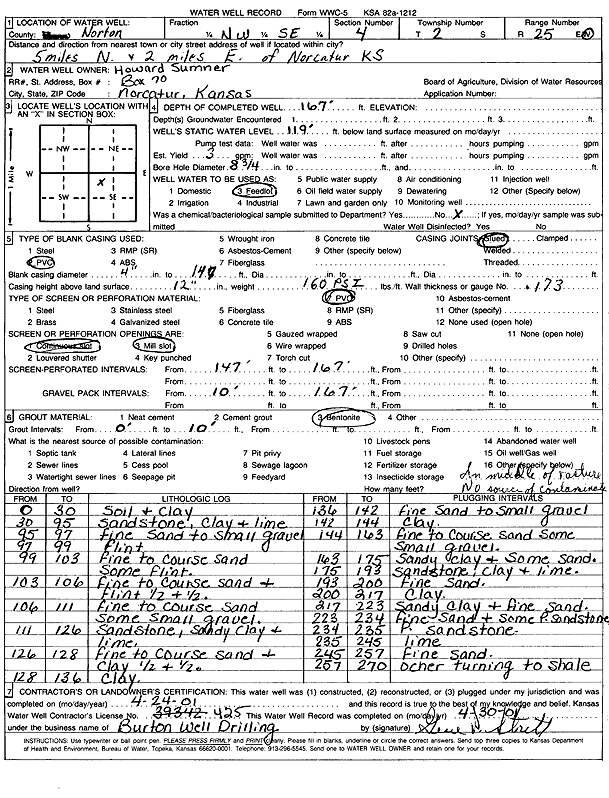
Specific Water Well Detail |
|
|
| Location Info | |||
| Owner: Sumner, Howard | Status: Constructed | ||
| Location: T2S, R25W, Sec. 4, NE NW SE | County: Norton | ||
| Directions: from Norcatur, 5 mi N and 2 mi E | |||
| Latitude: 39.9063423 | Longitude: -100.1380622 | Datum NAD 27 | |
| Latitude: 39.9063477 | Longitude: -100.1384742 | Datum NAD 83 | |
| Longitude and latitude calculated by Survey from township-range-section-quarter calls. Only good to within the quarter call accuracy. | |||
| View well on interactive map | |||
| General Info | ||
| Well Depth: 167 ft. | Elevation: ft. | |
| Static Water Level: 119 ft. | Est. Yield: 3 gpm. | |
| Comp. Date: 24-Apr-2001 | Well Use: Domestic, Livestock | |
| DWR Applic. #: | Other ID: | |
| Driller Info | ||
| Driller: Burton Well Drilling, Inc. | License #: 425 | |
| Scanned Form | View scan |
|
Chemical Sample Submitted?:
Water Well disinfected?: | ||
| Casing Info | ||
| Casing Type:
Casing Joints: |
Diam: in. to ft | |
| Casing height above land surface: in
Casing Weight: lbs/ft Wall thickness or gauge no.: | ||
| Screen and Perforation Info | ||
| Screen Type: | Screen Openings: | |
| Screen-perforated intervals | From: ft to ft | |
| Gravel pack intervals | From: ft to ft | |
| Grout Info | ||
| Grout used: | From: to ft | |
| Source of Possible Contamination | ||
| Source: | ||
| Direction from well: | Distance: ft | |
| Lithologic Log
(Log data entered by KGS.) | ||
| From: 0 ft. to 30 ft. | soil and clay | |
| From: 30 ft. to 95 ft. | sandstone, clay and lime | |
| From: 95 ft. to 97 ft. | fine sand to small gravel | |
| From: 97 ft. to 99 ft. | flint | |
| From: 99 ft. to 103 ft. | fine to coarse sand, some flint | |
| From: 103 ft. to 106 ft. | fine to coarse sand and flint, half and half | |
| From: 106 ft. to 111 ft. | fine to coarse sand, some small gravel | |
| From: 111 ft. to 126 ft. | sandstone, sandy clay, and lime | |
| From: 126 ft. to 128 ft. | fine to coarse sand and clay, half and half | |
| From: 128 ft. to 136 ft. | clay | |
| From: 136 ft. to 142 ft. | fine sand to small gravel | |
| From: 142 ft. to 144 ft. | clay | |
| From: 144 ft. to 163 ft. | fine to coarse sand some small gravel | |
| From: 163 ft. to 175 ft. | sandy clay and some sand | |
| From: 175 ft. to 193 ft. | sandstone, clay and lime | |
| From: 193 ft. to 200 ft. | fine sand | |
| From: 200 ft. to 217 ft. | clay | |
| From: 217 ft. to 223 ft. | sandy clay and fine sand | |
| From: 223 ft. to 234 ft. | fine sand and some p sandstone | |
| From: 234 ft. to 235 ft. | p sandstone | |
| From: 235 ft. to 245 ft. | lime | |
| From: 245 ft. to 257 ft. | fine sand | |
| From: 257 ft. to 270 ft. | ochre turning to shale | |