|
|
|
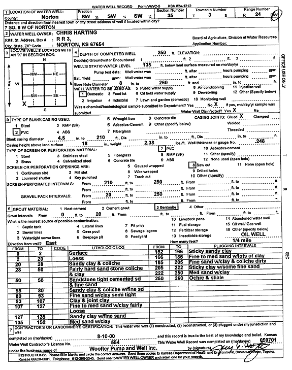
Specific Water Well Detail |
|
|
| Location Info | |||
| Owner: Harting, Chris | Status: Constructed | ||
| Location: T3S, R24W, Sec. 35, SW SW SW | County: Norton | ||
| Directions: from Norton: 7 mi S, 6 mi W | |||
| Latitude: 39.7415 | Longitude: -100.0006108 | Datum NAD 27 | |
| Latitude: 39.7415048 | Longitude: -100.0010161 | Datum NAD 83 | |
| Longitude and latitude calculated by Survey from township-range-section-quarter calls. Only good to within the quarter call accuracy. | |||
| View well on interactive map | |||
| General Info | ||
| Well Depth: 250 ft. | Elevation: ft. | |
| Static Water Level: 135 ft. | Est. Yield: gpm. | |
| Comp. Date: 10-Aug-2000 | Well Use: Domestic | |
| DWR Applic. #: | Other ID: | |
| Driller Info | ||
| Driller: Jay C. Woofter Pump & Well, Inc. | License #: 554 | |
| Scanned Form | View scan |
|
Chemical Sample Submitted?:
Water Well disinfected?: | ||
| Casing Info | ||
| Casing Type:
Casing Joints: |
Diam: in. to ft | |
| Casing height above land surface: in
Casing Weight: lbs/ft Wall thickness or gauge no.: | ||
| Screen and Perforation Info | ||
| Screen Type: | Screen Openings: | |
| Screen-perforated intervals | From: ft to ft | |
| Gravel pack intervals | From: ft to ft | |
| Grout Info | ||
| Grout used: | From: to ft | |
| Source of Possible Contamination | ||
| Source: | ||
| Direction from well: | Distance: ft | |
| Lithologic Log
(Log data entered by KGS.) | ||
| From: 0 ft. to 2 ft. | surface | |
| From: 2 ft. to 20 ft. | loess | |
| From: 20 ft. to 28 ft. | sandy clay and caliche | |
| From: 28 ft. to 50 ft. | fairly hard sandstone, caliche, and clay | |
| From: 50 ft. to 58 ft. | sandstone, tight cemented sand, and fine sand | |
| From: 58 ft. to 80 ft. | sandy clay and caliche with fine sand | |
| From: 80 ft. to 93 ft. | fine sand with clay, semi tight | |
| From: 93 ft. to 107 ft. | clay and joint clay | |
| From: 107 ft. to 127 ft. | fine to medium sand with clay, fairly loose | |
| From: 127 ft. to 135 ft. | sandy clay with fine sand | |
| From: 135 ft. to 152 ft. | medium sand with clay | |
| From: 152 ft. to 166 ft. | sticky sandy clay | |
| From: 166 ft. to 185 ft. | fine to medium sand with lots of clay | |
| From: 185 ft. to 205 ft. | fine sand with clay and caliche, dirty | |
| From: 205 ft. to 222 ft. | sticky clay with some fine sand | |
| From: 222 ft. to 250 ft. | medium sand with clay | |
| From: 250 ft. to 260 ft. | ochre and shale | |