|
|
|
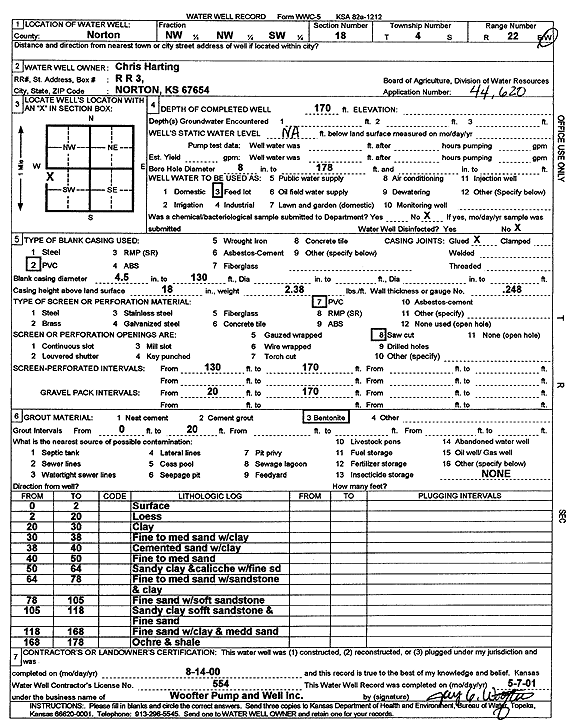
Specific Water Well Detail |
|
|
| Location Info | |||
| Owner: Harting, Chris | Status: Constructed | ||
| Location: T4S, R22W, Sec. 18, NW NW SW | County: Norton | ||
| Directions: | |||
| Latitude: 39.7036267 | Longitude: -99.8508742 | Datum NAD 27 | |
| Latitude: 39.7036322 | Longitude: -99.8512725 | Datum NAD 83 | |
| Longitude and latitude calculated by Survey from township-range-section-quarter calls. Only good to within the quarter call accuracy. | |||
| View well on interactive map | |||
| General Info | ||
| Well Depth: 170 ft. | Elevation: ft. | |
| Static Water Level: ft. | Est. Yield: gpm. | |
| Comp. Date: 14-Aug-2000 | Well Use: Feedlot | |
| DWR Applic. #: 44620 | Other ID: | |
| Links | |
| View info from Wizard Water Level Data base... | |
| View info from WIMAS Water Right Data base... | |
| Driller Info | ||
| Driller: Jay C. Woofter Pump & Well, Inc. | License #: 554 | |
| Scanned Form | View scan |
|
Chemical Sample Submitted?:
Water Well disinfected?: | ||
| Casing Info | ||
| Casing Type:
Casing Joints: |
Diam: in. to ft | |
| Casing height above land surface: in
Casing Weight: lbs/ft Wall thickness or gauge no.: | ||
| Screen and Perforation Info | ||
| Screen Type: | Screen Openings: | |
| Screen-perforated intervals | From: ft to ft | |
| Gravel pack intervals | From: ft to ft | |
| Grout Info | ||
| Grout used: | From: to ft | |
| Source of Possible Contamination | ||
| Source: | ||
| Direction from well: | Distance: ft | |
| Lithologic Log
(Log data entered by KGS.) | ||
| From: 0 ft. to 2 ft. | surface | |
| From: 2 ft. to 20 ft. | loess | |
| From: 20 ft. to 30 ft. | clay | |
| From: 30 ft. to 38 ft. | fine to medium sand with clay | |
| From: 38 ft. to 40 ft. | cemented sand with clay | |
| From: 40 ft. to 50 ft. | fine to medium sand | |
| From: 50 ft. to 64 ft. | sandy clay and caliche with fine sand | |
| From: 64 ft. to 78 ft. | fine to medium sand with sandstone and clay | |
| From: 78 ft. to 105 ft. | fine sand with soft sandstone | |
| From: 105 ft. to 118 ft. | sandy clay, soft sandstone, and fine sand | |
| From: 118 ft. to 168 ft. | fine sand with clay and medium sand | |
| From: 168 ft. to 178 ft. | ochre and shale | |