|
|
|
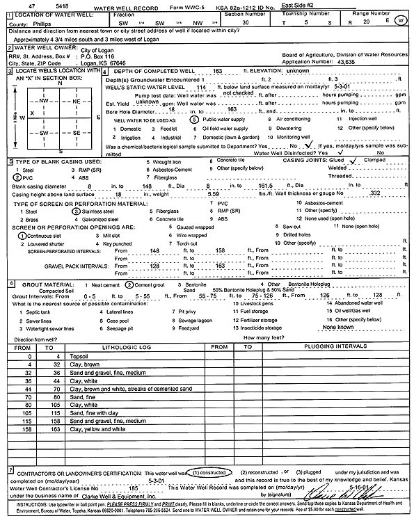
Specific Water Well Detail |
|
|
| Location Info | |||
| Owner: City of Logan | Status: Constructed | ||
| Location: T5S, R20W, Sec. 30, SW SW NW | County: Phillips | ||
| Directions: from Logan: 4.75 mi S, 3 mi W | |||
| Latitude: 39.5900414 | Longitude: -99.6263363 | Datum NAD 27 | |
| Latitude: 39.5900488 | Longitude: -99.6267245 | Datum NAD 83 | |
| Longitude and latitude calculated by Survey from township-range-section-quarter calls. Only good to within the quarter call accuracy. | |||
| View well on interactive map | |||
| General Info | ||
| Well Depth: 163 ft. | Elevation: ft. | |
| Static Water Level: 114 ft. | Est. Yield: gpm. | |
| Comp. Date: 03-May-2001 | Well Use: Public Water Supply | |
| DWR Applic. #: 43636 | Other ID: East side 2 | |
| Links | |
| No Wizard information available. | |
| View info from WIMAS Water Right Data base... | |
| Driller Info | ||
| Driller: Clarke Well and Equipment, Inc. | License #: 185 | |
| Scanned Form | View scan |
|
Chemical Sample Submitted?:
Water Well disinfected?: | ||
| Casing Info | ||
| Casing Type:
Casing Joints: |
Diam: in. to ft | |
| Casing height above land surface: in
Casing Weight: lbs/ft Wall thickness or gauge no.: | ||
| Screen and Perforation Info | ||
| Screen Type: | Screen Openings: | |
| Screen-perforated intervals | From: ft to ft | |
| Gravel pack intervals | From: ft to ft | |
| Grout Info | ||
| Grout used: | From: to ft | |
| Source of Possible Contamination | ||
| Source: | ||
| Direction from well: | Distance: ft | |
| Lithologic Log
(Log data entered by KGS.) | ||
| From: 0 ft. to 4 ft. | top soil | |
| From: 4 ft. to 32 ft. | clay, brown | |
| From: 32 ft. to 36 ft. | sand and gravel, fine, medium | |
| From: 36 ft. to 44 ft. | clay, white | |
| From: 44 ft. to 70 ft. | clay, brown and white, streaks of cemented sand | |
| From: 70 ft. to 80 ft. | sand, fine | |
| From: 80 ft. to 105 ft. | clay, white | |
| From: 105 ft. to 115 ft. | sand, fine with gray | |
| From: 115 ft. to 158 ft. | sand and gravel, fine, medium | |
| From: 158 ft. to 163 ft. | clay, yellow and white | |