|
|
|
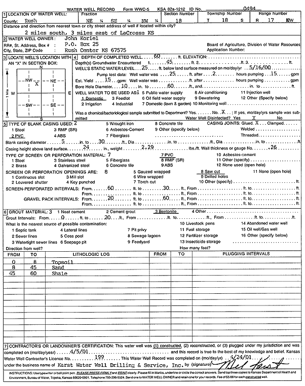
Specific Water Well Detail |
|
|
| Location Info | |||
| Owner: Koriel, John | Status: Constructed | ||
| Location: T18S, R17W, Sec. 18, NE SE NW | County: Rush | ||
| Directions: from La Crosse: 2 mi S, 3 mi E | |||
| Latitude: 38.4896554 | Longitude: -99.2450846 | Datum NAD 27 | |
| Latitude: 38.4896686 | Longitude: -99.2454647 | Datum NAD 83 | |
| Longitude and latitude calculated by Survey from township-range-section-quarter calls. Only good to within the quarter call accuracy. | |||
| View well on interactive map | |||
| General Info | ||
| Well Depth: 60 ft. | Elevation: ft. | |
| Static Water Level: 25 ft. | Est. Yield: 15 gpm. | |
| Comp. Date: 05-Apr-2001 | Well Use: Domestic | |
| DWR Applic. #: | Other ID: | |
| Driller Info | ||
| Driller: Melvin B. Karst Water Well Drilling & Service, Inc. | License #: 199 | |
| Scanned Form | View scan |
|
Chemical Sample Submitted?:
Water Well disinfected?: | ||
| Casing Info | ||
| Casing Type:
Casing Joints: |
Diam: in. to ft | |
| Casing height above land surface: in
Casing Weight: lbs/ft Wall thickness or gauge no.: | ||
| Screen and Perforation Info | ||
| Screen Type: | Screen Openings: | |
| Screen-perforated intervals | From: ft to ft | |
| Gravel pack intervals | From: ft to ft | |
| Grout Info | ||
| Grout used: | From: to ft | |
| Source of Possible Contamination | ||
| Source: | ||
| Direction from well: | Distance: ft | |
| Lithologic Log
(Log data entered by KGS.) | ||
| From: 0 ft. to 8 ft. | topsoil | |
| From: 8 ft. to 45 ft. | sand | |
| From: 45 ft. to 60 ft. | shale | |