|
|
|
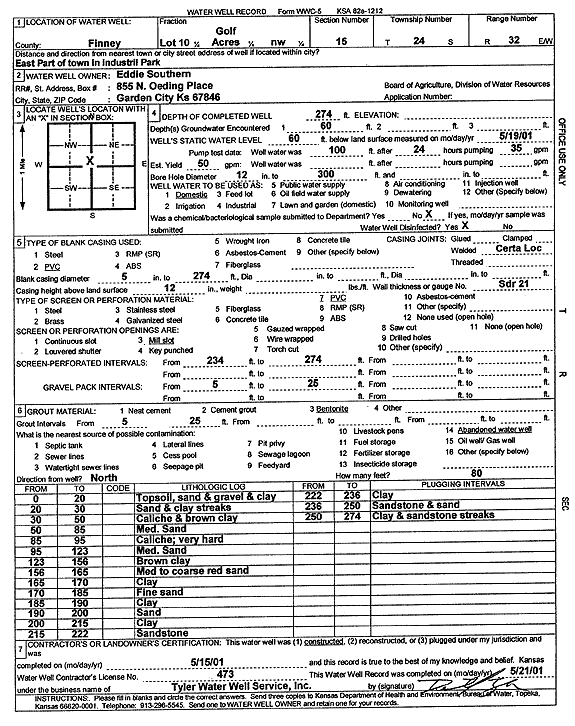
Specific Water Well Detail |
|
|
| Location Info | |||
| Owner: Southern, Eddie | Status: Constructed | ||
| Location: T24S, R32W, Sec. 15, NW | County: Finney | ||
| Directions: E part of town in Industrial Park | |||
| Latitude: 37.9711894 | Longitude: -100.8238246 | Datum NAD 27 | |
| Latitude: 37.9712121 | Longitude: -100.8242624 | Datum NAD 83 | |
| Longitude and latitude calculated by Survey from township-range-section-quarter calls. Only good to within the quarter call accuracy. | |||
| View well on interactive map | |||
| General Info | ||
| Well Depth: 274 ft. | Elevation: ft. | |
| Static Water Level: 60 ft. | Est. Yield: gpm. | |
| Comp. Date: 15-May-2001 | Well Use: Domestic | |
| DWR Applic. #: | Other ID: | |
| Driller Info | ||
| Driller: Destal Tyler Water Well Service | License #: 473 | |
| Scanned Form | View scan |
|
Chemical Sample Submitted?:
Water Well disinfected?: | ||
| Casing Info | ||
| Casing Type:
Casing Joints: |
Diam: in. to ft | |
| Casing height above land surface: in
Casing Weight: lbs/ft Wall thickness or gauge no.: | ||
| Screen and Perforation Info | ||
| Screen Type: | Screen Openings: | |
| Screen-perforated intervals | From: ft to ft | |
| Gravel pack intervals | From: ft to ft | |
| Grout Info | ||
| Grout used: | From: to ft | |
| Source of Possible Contamination | ||
| Source: | ||
| Direction from well: | Distance: ft | |
| Lithologic Log
(Log data entered by KGS.) | ||
| From: 0 ft. to 20 ft. | topsoil, sand and gravel and clay | |
| From: 20 ft. to 30 ft. | sand and clay streaks | |
| From: 30 ft. to 50 ft. | caliche and brown clay | |
| From: 50 ft. to 85 ft. | medium sand | |
| From: 85 ft. to 95 ft. | caliche; very hard | |
| From: 95 ft. to 123 ft. | medium sand | |
| From: 123 ft. to 156 ft. | brown clay | |
| From: 156 ft. to 165 ft. | med to coarse red sand | |
| From: 165 ft. to 170 ft. | clay | |
| From: 170 ft. to 185 ft. | fine sand | |
| From: 185 ft. to 190 ft. | clay | |
| From: 190 ft. to 200 ft. | sand | |
| From: 200 ft. to 215 ft. | clay | |
| From: 215 ft. to 222 ft. | sandstone | |
| From: 222 ft. to 236 ft. | clay | |
| From: 236 ft. to 250 ft. | sandstone and sand | |
| From: 250 ft. to 274 ft. | clay and sandstone streaks | |