|
|
|
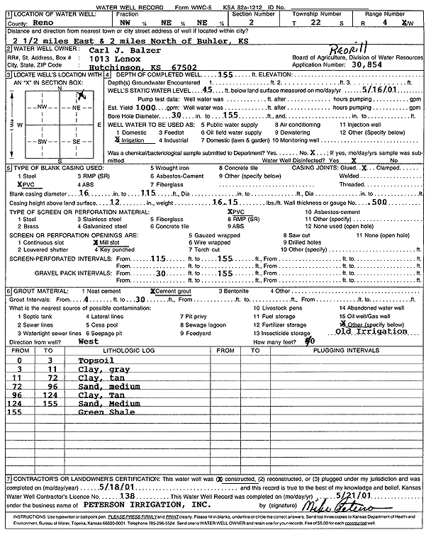
Specific Water Well Detail |
|
|
| Location Info | |||
| Owner: Balzer, Carl J. | Status: Constructed | ||
| Location: T22S, R4W, Sec. 2, NW NE NE | County: Reno | ||
| Directions: from Buhler: 2.5 mi E, 2 mi N | |||
| Latitude: 38.1728828 | Longitude: -97.7234102 | Datum NAD 27 | |
| Latitude: 38.1728926 | Longitude: -97.7237344 | Datum NAD 83 | |
| Longitude and latitude calculated by Survey from township-range-section-quarter calls. Only good to within the quarter call accuracy. | |||
| View well on interactive map | |||
| General Info | ||
| Well Depth: 155 ft. | Elevation: ft. | |
| Static Water Level: 45 ft. | Est. Yield: 1000 gpm. | |
| Comp. Date: 18-May-2001 | Well Use: Irrigation | |
| DWR Applic. #: 30854 | Other ID: | |
| Links | |
| View info from Wizard Water Level Data base... | |
| View info from WIMAS Water Right Data base... | |
| Driller Info | ||
| Driller: Michael Peterson Irrigation, Inc. | License #: 138 | |
| Scanned Form | View scan |
|
Chemical Sample Submitted?:
Water Well disinfected?: | ||
| Casing Info | ||
| Casing Type:
Casing Joints: |
Diam: in. to ft | |
| Casing height above land surface: in
Casing Weight: lbs/ft Wall thickness or gauge no.: | ||
| Screen and Perforation Info | ||
| Screen Type: | Screen Openings: | |
| Screen-perforated intervals | From: ft to ft | |
| Gravel pack intervals | From: ft to ft | |
| Grout Info | ||
| Grout used: | From: to ft | |
| Source of Possible Contamination | ||
| Source: | ||
| Direction from well: | Distance: ft | |
| Lithologic Log
(Log data entered by KGS.) | ||
| From: 0 ft. to 3 ft. | top soil | |
| From: 3 ft. to 11 ft. | clay, gray | |
| From: 11 ft. to 72 ft. | clay, tan | |
| From: 72 ft. to 96 ft. | sand, medium | |
| From: 96 ft. to 124 ft. | clay, tan | |
| From: 124 ft. to 155 ft. | sand, medium | |
| From: 155 ft. to ft. | green shale | |