|
|
|
Specific Water Well Detail |
|
|
| Location Info | |||
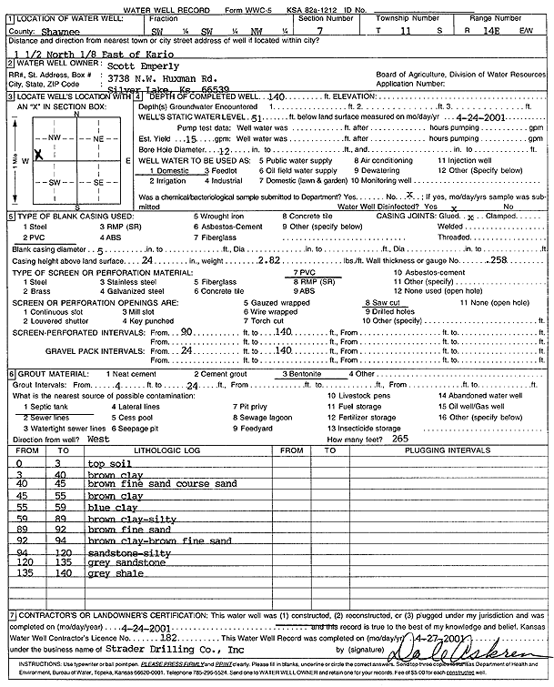
| Owner: Emperly, Scott | Status: Constructed | ||
| Location: T11S, R14E, Sec. 7, SW SW NW | County: Shawnee | ||
| Directions: from Kario: 1.5 mi N, .13 mi E | |||
| Latitude: 39.1097483 | Longitude: -95.9083306 | Datum NAD 27 | |
| Latitude: 39.1097474 | Longitude: -95.9085966 | Datum NAD 83 | |
| Longitude and latitude calculated by Survey from township-range-section-quarter calls. Only good to within the quarter call accuracy. | |||
| View well on interactive map | |||
| General Info | ||
| Well Depth: 140 ft. | Elevation: ft. | |
| Static Water Level: 51 ft. | Est. Yield: 15 gpm. | |
| Comp. Date: 24-Apr-2001 | Well Use: Domestic | |
| DWR Applic. #: | Other ID: | |
| Driller Info | ||
| Driller: Strader Drilling Co., Inc. | License #: 182 | |
| Scanned Form | View scan |
|
Chemical Sample Submitted?:
Water Well disinfected?: | ||
| Casing Info | ||
| Casing Type:
Casing Joints: |
Diam: in. to ft | |
| Casing height above land surface: in
Casing Weight: lbs/ft Wall thickness or gauge no.: | ||
| Screen and Perforation Info | ||
| Screen Type: | Screen Openings: | |
| Screen-perforated intervals | From: ft to ft | |
| Gravel pack intervals | From: ft to ft | |
| Grout Info | ||
| Grout used: | From: to ft | |
| Source of Possible Contamination | ||
| Source: | ||
| Direction from well: | Distance: ft | |
| Lithologic Log
(Log data entered by KGS.) | ||
| From: 0 ft. to 3 ft. | top soil | |
| From: 3 ft. to 40 ft. | brown clay | |
| From: 40 ft. to 45 ft. | brown fine sand and coarse sand | |
| From: 45 ft. to 55 ft. | brown clay | |
| From: 55 ft. to 59 ft. | blue clay | |
| From: 59 ft. to 89 ft. | brown clay, silty | |
| From: 89 ft. to 92 ft. | brown fine sand | |
| From: 92 ft. to 94 ft. | brown clay and brown fine sand | |
| From: 94 ft. to 120 ft. | sandstone, silty | |
| From: 120 ft. to 135 ft. | gray sandstone | |
| From: 135 ft. to 140 ft. | gray shale | |