|
|
|
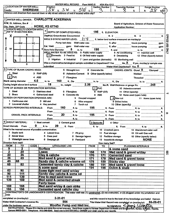
Specific Water Well Detail |
|
|
| Location Info | |||
| Owner: Ackerman, Charlotte | Status: Constructed | ||
| Location: T8S, R28W, Sec. 3, SW SW SW | County: Sheridan | ||
| Directions: | |||
| Latitude: 39.3801982 | Longitude: -100.4403575 | Datum NAD 27 | |
| Latitude: 39.3802029 | Longitude: -100.4407757 | Datum NAD 83 | |
| Longitude and latitude calculated by Survey from township-range-section-quarter calls. Only good to within the quarter call accuracy. | |||
| View well on interactive map | |||
| General Info | ||
| Well Depth: 195 ft. | Elevation: ft. | |
| Static Water Level: 114 ft. | Est. Yield: gpm. | |
| Comp. Date: 31-Mar-2001 | Well Use: Domestic | |
| DWR Applic. #: | Other ID: | |
| Driller Info | ||
| Driller: Jay C. Woofter Pump & Well, Inc. | License #: 554 | |
| Scanned Form | View scan |
|
Chemical Sample Submitted?:
Water Well disinfected?: | ||
| Casing Info | ||
| Casing Type:
Casing Joints: |
Diam: in. to ft | |
| Casing height above land surface: in
Casing Weight: lbs/ft Wall thickness or gauge no.: | ||
| Screen and Perforation Info | ||
| Screen Type: | Screen Openings: | |
| Screen-perforated intervals | From: ft to ft | |
| Gravel pack intervals | From: ft to ft | |
| Grout Info | ||
| Grout used: | From: to ft | |
| Source of Possible Contamination | ||
| Source: | ||
| Direction from well: | Distance: ft | |
| Lithologic Log
(Log data entered by KGS.) | ||
| From: 0 ft. to 2 ft. | Surface | |
| From: 2 ft. to 20 ft. | Loess | |
| From: 20 ft. to 36 ft. | Clay and caliche | |
| From: 36 ft. to 49 ft. | Medium sand and gravel with clay | |
| From: 49 ft. to 65 ft. | Sandy clay and caliche with some sand | |
| From: 65 ft. to 82 ft. | Cemented sandy clay and caliche and some sand | |
| From: 82 ft. to 90 ft. | Some tight medium sand with clay | |
| From: 90 ft. to 111 ft. | Sandy clay caliche and some sand | |
| From: 111 ft. to 130 ft. | Fine to medium sand loose | |
| From: 130 ft. to 150 ft. | Medium sand and cemented streak fairly loose | |
| From: 150 ft. to 155 ft. | Medium sand with clay and cemented streaks | |
| From: 155 ft. to 158 ft. | Cemented sand caliche clay and some sand | |
| From: 158 ft. to 170 ft. | Medium sand and gravel with clay | |
| From: 170 ft. to 171 ft. | Cemented sand | |
| From: 171 ft. to 178 ft. | Medium sand and gravel loose | |
| From: 178 ft. to 180 ft. | Sticky clay | |
| From: 180 ft. to 191 ft. | Medium sand and gravel loose | |
| From: 191 ft. to 195 ft. | Ochre and shale | |