|
|
|
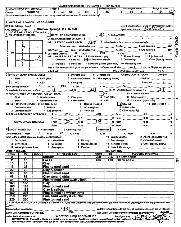
Specific Water Well Detail |
|
|
| Location Info | |||
| Owner: Akers, John | Status: Constructed | ||
| Location: T11S, R41W, Sec. 35, E2 NE SE | County: Wallace | ||
| Directions: | |||
| Latitude: 39.0516483 | Longitude: -101.832089 | Datum NAD 27 | |
| Latitude: 39.0516535 | Longitude: -101.8325407 | Datum NAD 83 | |
| Longitude and latitude calculated by Survey from township-range-section-quarter calls. Only good to within the quarter call accuracy. | |||
| View well on interactive map | |||
| General Info | ||
| Well Depth: 250 ft. | Elevation: ft. | |
| Static Water Level: 167 ft. | Est. Yield: gpm. | |
| Comp. Date: 03-Apr-2001 | Well Use: Oil Field Water Supply | |
| DWR Applic. #: 20010051 | Other ID: | |
| Links | |
| No Wizard information available. | |
| View info from WIMAS Water Right Data base... | |
| Driller Info | ||
| Driller: Jay C. Woofter Pump & Well, Inc. | License #: 554 | |
| Scanned Form | View scan |
|
Chemical Sample Submitted?:
Water Well disinfected?: | ||
| Casing Info | ||
| Casing Type:
Casing Joints: |
Diam: in. to ft | |
| Casing height above land surface: in
Casing Weight: lbs/ft Wall thickness or gauge no.: | ||
| Screen and Perforation Info | ||
| Screen Type: | Screen Openings: | |
| Screen-perforated intervals | From: ft to ft | |
| Gravel pack intervals | From: ft to ft | |
| Grout Info | ||
| Grout used: | From: to ft | |
| Source of Possible Contamination | ||
| Source: | ||
| Direction from well: | Distance: ft | |
| Lithologic Log
(Log data entered by KGS.) | ||
| From: 0 ft. to 2 ft. | Surface | |
| From: 2 ft. to 10 ft. | Loess | |
| From: 10 ft. to 15 ft. | Clay | |
| From: 15 ft. to 22 ft. | Fine to medium sand | |
| From: 22 ft. to 39 ft. | Clay and caliche | |
| From: 39 ft. to 68 ft. | Fine to medium sand | |
| From: 68 ft. to 81 ft. | Clay with sand streaks | |
| From: 81 ft. to 160 ft. | Fine to medium sand with clay lens | |
| From: 160 ft. to 165 ft. | Clay | |
| From: 165 ft. to 183 ft. | Fine to medium sand | |
| From: 183 ft. to 189 ft. | Clay and caliche | |
| From: 189 ft. to 201 ft. | Fine to medium sand with clay streaks | |
| From: 210 ft. to 220 ft. | Fine sand with clay and caliche | |
| From: 220 ft. to 250 ft. | Fine to medium sand | |
| From: 250 ft. to 265 ft. | Yellow ochre | |
| From: 265 ft. to 273 ft. | Black shale | |