|
|
|
Specific Water Well Detail |
|
|
| Location Info | |||
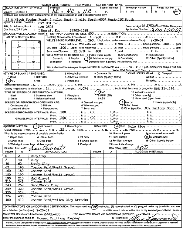
| Owner: Oxy USA, Inc. | Status: Constructed | ||
| Location: T27S, R33W, Sec. 19, NE NE NE | County: Haskell | ||
| Directions: from 83 and Hitch Feeder Rd: 5 mi W, 1 mi N, 600 feet W, and 410 feet S | |||
| Latitude: 37.6920685 | Longitude: -100.9625816 | Datum NAD 27 | |
| Latitude: 37.6920925 | Longitude: -100.9630268 | Datum NAD 83 | |
| Longitude and latitude calculated by Survey from township-range-section-quarter calls. Only good to within the quarter call accuracy. | |||
| View well on interactive map | |||
| General Info | ||
| Well Depth: 400 ft. | Elevation: ft. | |
| Static Water Level: 260 ft. | Est. Yield: gpm. | |
| Comp. Date: 20-Feb-2001 | Well Use: Oil Field Water Supply | |
| DWR Applic. #: 20010037 | Other ID: Frey G 1 | |
| Links | |
| No Wizard information available. | |
| View info from WIMAS Water Right Data base... | |
| Driller Info | ||
| Driller: Howard Drilling Company AG, LLC | License #: 430 | |
| Scanned Form | View scan |
|
Chemical Sample Submitted?:
Water Well disinfected?: | ||
| Casing Info | ||
| Casing Type:
Casing Joints: |
Diam: in. to ft | |
| Casing height above land surface: in
Casing Weight: lbs/ft Wall thickness or gauge no.: | ||
| Screen and Perforation Info | ||
| Screen Type: | Screen Openings: | |
| Screen-perforated intervals | From: ft to ft | |
| Gravel pack intervals | From: ft to ft | |
| Grout Info | ||
| Grout used: | From: to ft | |
| Source of Possible Contamination | ||
| Source: | ||
| Direction from well: | Distance: ft | |
| Lithologic Log
(Log data entered by KGS.) | ||
| From: 0 ft. to 2 ft. | clay/top | |
| From: 2 ft. to 40 ft. | clay | |
| From: 40 ft. to 62 ft. | sandy clay | |
| From: 62 ft. to 160 ft. | coarse sand/small gravel | |
| From: 160 ft. to 180 ft. | coarse sand | |
| From: 180 ft. to 190 ft. | coarse sand/small gravel | |
| From: 190 ft. to 210 ft. | med gravel | |
| From: 210 ft. to 243 ft. | coarse sand | |
| From: 243 ft. to 259 ft. | sand/sandy clay | |
| From: 259 ft. to 320 ft. | coarse sand/small gravel | |
| From: 320 ft. to 324 ft. | clay | |
| From: 324 ft. to 400 ft. | coarse sand | |
| From: 400 ft. to 410 ft. | coarse sand / yellow clay streaks | |