|
|
|
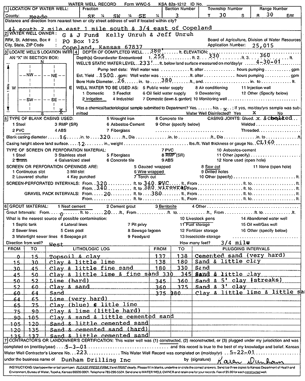
Specific Water Well Detail |
|
|
| Location Info | |||
| Owner: G and J Fund | Status: Constructed | ||
| Location: T30S, R30W, Sec. 3, SE SW SE | County: Meade | ||
| Directions: from Copeland: 4.5 mi S, 2 mi E, 1 mi S, .75 mi E | |||
| Latitude: 37.461079 | Longitude: -100.584758 | Datum NAD 27 | |
| Latitude: 37.4611027 | Longitude: -100.5851897 | Datum NAD 83 | |
| Longitude and latitude calculated by Survey from township-range-section-quarter calls. Only good to within the quarter call accuracy. | |||
| View well on interactive map | |||
| General Info | ||
| Well Depth: 380 ft. | Elevation: ft. | |
| Static Water Level: 233 ft. | Est. Yield: 1500 gpm. | |
| Comp. Date: 03-May-2001 | Well Use: Irrigation | |
| DWR Applic. #: 25015 | Other ID: | |
| Links | |
| No Wizard information available. | |
| View info from WIMAS Water Right Data base... | |
| Driller Info | ||
| Driller: Donald R. Dunham Drilling, Inc. | License #: 223 | |
| Scanned Form | View scan |
|
Chemical Sample Submitted?:
Water Well disinfected?: | ||
| Casing Info | ||
| Casing Type:
Casing Joints: |
Diam: in. to ft | |
| Casing height above land surface: in
Casing Weight: lbs/ft Wall thickness or gauge no.: | ||
| Screen and Perforation Info | ||
| Screen Type: | Screen Openings: | |
| Screen-perforated intervals | From: ft to ft | |
| Gravel pack intervals | From: ft to ft | |
| Grout Info | ||
| Grout used: | From: to ft | |
| Source of Possible Contamination | ||
| Source: | ||
| Direction from well: | Distance: ft | |
| Lithologic Log
(Log data entered by KGS.) | ||
| From: 0 ft. to 15 ft. | top soil and clay | |
| From: 15 ft. to 30 ft. | clay and little limestone | |
| From: 30 ft. to 45 ft. | clay and little fine sand | |
| From: 45 ft. to 50 ft. | clay and little limestone and fine sand | |
| From: 50 ft. to 52 ft. | limestone, hard | |
| From: 52 ft. to 60 ft. | clay and sand | |
| From: 60 ft. to 64 ft. | sand | |
| From: 64 ft. to 65 ft. | limestone, very hard | |
| From: 65 ft. to 75 ft. | clay, blue, and little limestone | |
| From: 75 ft. to 90 ft. | clay and limestone, little hard | |
| From: 90 ft. to 105 ft. | clay and sand and little cemented sand | |
| From: 105 ft. to 120 ft. | sand and little cemented sand | |
| From: 120 ft. to 135 ft. | sand and cemented sand, hard | |
| From: 135 ft. to 137 ft. | sand and little cemented sand | |
| From: 137 ft. to 138 ft. | cemented sand, very hard | |
| From: 138 ft. to 180 ft. | sand and little clay | |
| From: 180 ft. to 330 ft. | sand | |
| From: 330 ft. to 345 ft. | sand and little clay | |
| From: 345 ft. to 360 ft. | sand and 5-foot clay streaks | |
| From: 360 ft. to 375 ft. | sand and 3-foot clay | |
| From: 375 ft. to 380 ft. | clay and little limestone and little sand | |