|
|
|
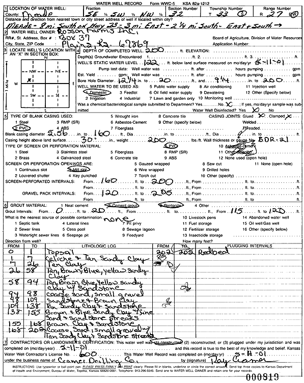
Specific Water Well Detail |
|
|
| Location Info | |||
| Owner: Rosson Farms Inc. | Status: Constructed | ||
| Location: T33S, R27W, Sec. 32, SE SW NW | County: Meade | ||
| Directions: from Meade: 8 mi S on Hwy 23, 3 mi E, 2.25 mi S, E and S into lot | |||
| Latitude: 37.1336942 | Longitude: -100.2863555 | Datum NAD 27 | |
| Latitude: 37.1337204 | Longitude: -100.2867774 | Datum NAD 83 | |
| Longitude and latitude calculated by Survey from township-range-section-quarter calls. Only good to within the quarter call accuracy. | |||
| View well on interactive map | |||
| General Info | ||
| Well Depth: 200 ft. | Elevation: ft. | |
| Static Water Level: 122 ft. | Est. Yield: gpm. | |
| Comp. Date: 11-Feb-2001 | Well Use: Domestic | |
| DWR Applic. #: | Other ID: | |
| Driller Info | ||
| Driller: Ray Cramer Drilling Co. | License #: 600 | |
| Scanned Form | View scan |
|
Chemical Sample Submitted?:
Water Well disinfected?: | ||
| Casing Info | ||
| Casing Type:
Casing Joints: |
Diam: in. to ft | |
| Casing height above land surface: in
Casing Weight: lbs/ft Wall thickness or gauge no.: | ||
| Screen and Perforation Info | ||
| Screen Type: | Screen Openings: | |
| Screen-perforated intervals | From: ft to ft | |
| Gravel pack intervals | From: ft to ft | |
| Grout Info | ||
| Grout used: | From: to ft | |
| Source of Possible Contamination | ||
| Source: | ||
| Direction from well: | Distance: ft | |
| Lithologic Log
(Log data entered by KGS.) | ||
| From: 0 ft. to 1 ft. | top soil | |
| From: 1 ft. to 7 ft. | caliche and tan sandy clay | |
| From: 7 ft. to 26 ft. | tan clay | |
| From: 26 ft. to 58 ft. | tan, brown, blue, yellow sandy clay | |
| From: 58 ft. to 94 ft. | tan, brown, blue, yellow sandy clay with sandstone | |
| From: 94 ft. to 98 ft. | coarse sand, small gravel | |
| From: 98 ft. to 109 ft. | sandstone and brown clay | |
| From: 109 ft. to 138 ft. | tan sandy clay and sandstone | |
| From: 138 ft. to 155 ft. | brown and blue sand clay with fine sand and sandstone streaks | |
| From: 155 ft. to 168 ft. | brown clay and sandstone | |
| From: 168 ft. to 202 ft. | coarse sand, small gravel with tan sandy clay and sandstone streaks | |
| From: 202 ft. to 205 ft. | red bed | |