|
|
|
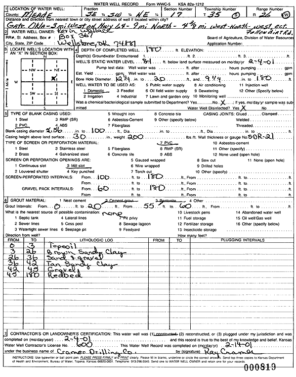
Specific Water Well Detail |
|
|
| Location Info | |||
| Owner: Wallace, Kevin | Status: Constructed | ||
| Location: T35S, R26W, Sec. 17, SE SW NE | County: Meade | ||
| Directions: from Gate, OK: 3 mi W on Hwy 64, 9 mi N, 4.38 W, NW ect., follow dirt rd | |||
| Latitude: 37.0053865 | Longitude: -100.1667915 | Datum NAD 27 | |
| Latitude: 37.0054151 | Longitude: -100.1672101 | Datum NAD 83 | |
| Longitude and latitude calculated by Survey from township-range-section-quarter calls. Only good to within the quarter call accuracy. | |||
| View well on interactive map | |||
| General Info | ||
| Well Depth: 180 ft. | Elevation: ft. | |
| Static Water Level: 81 ft. | Est. Yield: gpm. | |
| Comp. Date: 04-Feb-2001 | Well Use: Domestic | |
| DWR Applic. #: | Other ID: | |
| Driller Info | ||
| Driller: Ray Cramer Drilling Co. | License #: 600 | |
| Scanned Form | View scan |
|
Chemical Sample Submitted?:
Water Well disinfected?: | ||
| Casing Info | ||
| Casing Type:
Casing Joints: |
Diam: in. to ft | |
| Casing height above land surface: in
Casing Weight: lbs/ft Wall thickness or gauge no.: | ||
| Screen and Perforation Info | ||
| Screen Type: | Screen Openings: | |
| Screen-perforated intervals | From: ft to ft | |
| Gravel pack intervals | From: ft to ft | |
| Grout Info | ||
| Grout used: | From: to ft | |
| Source of Possible Contamination | ||
| Source: | ||
| Direction from well: | Distance: ft | |
| Lithologic Log
(Log data entered by KGS.) | ||
| From: 0 ft. to 3 ft. | top soil | |
| From: 3 ft. to 26 ft. | brown sandy clay | |
| From: 26 ft. to 36 ft. | sand and gravel | |
| From: 36 ft. to 42 ft. | tan sandy clay | |
| From: 42 ft. to 45 ft. | gravel | |
| From: 45 ft. to 180 ft. | red bed | |