|
|
|
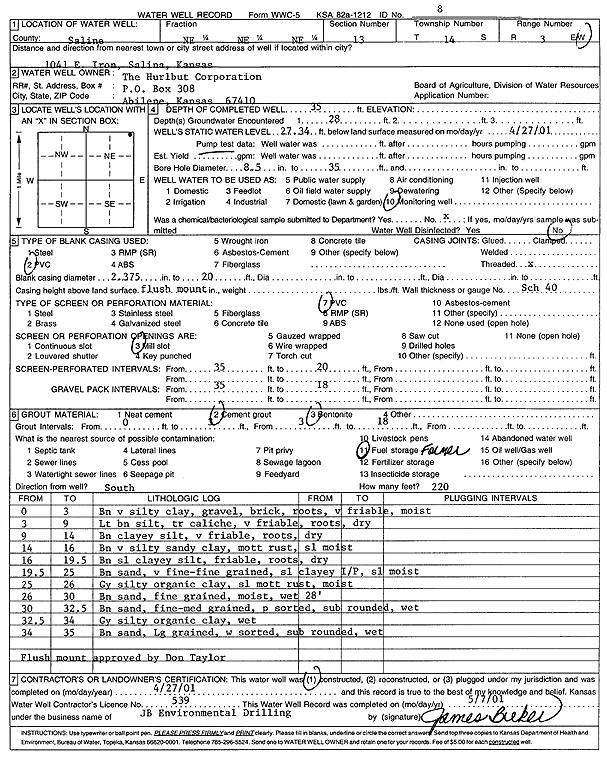
Specific Water Well Detail |
|
|
| Location Info | |||
| Owner: The Hurlbut Corp. | Status: Constructed | ||
| Location: T14S, R3W, Sec. 13, NE NE NE | County: Saline | ||
| Directions: 1041 E Iron, Salina | |||
| Latitude: 38.8405993 | Longitude: -97.5949085 | Datum NAD 27 | |
| Latitude: 38.8406025 | Longitude: -97.5952206 | Datum NAD 83 | |
| Longitude and latitude calculated by Survey from township-range-section-quarter calls. Only good to within the quarter call accuracy. | |||
| View well on interactive map | |||
| General Info | ||
| Well Depth: 35 ft. | Elevation: ft. | |
| Static Water Level: 27.34 ft. | Est. Yield: gpm. | |
| Comp. Date: 27-Apr-2001 | Well Use: Monitoring well/observation/piezometer | |
| DWR Applic. #: | Other ID: MW 8 | |
| Driller Info | ||
| Driller: JB Environmental Drilling | License #: 539 | |
| Scanned Form | View scan |
|
Chemical Sample Submitted?:
Water Well disinfected?: | ||
| Casing Info | ||
| Casing Type:
Casing Joints: |
Diam: in. to ft | |
| Casing height above land surface: in
Casing Weight: lbs/ft Wall thickness or gauge no.: | ||
| Screen and Perforation Info | ||
| Screen Type: | Screen Openings: | |
| Screen-perforated intervals | From: ft to ft | |
| Gravel pack intervals | From: ft to ft | |
| Grout Info | ||
| Grout used: | From: to ft | |
| Source of Possible Contamination | ||
| Source: | ||
| Direction from well: | Distance: ft | |
| Lithologic Log
(Log data entered by KGS.) | ||
| From: 0 ft. to 3 ft. | brown very silty clay, gravel, brick, roots, very friable, moist | |
| From: 3 ft. to 9 ft. | light brown silt, trace caliche, very friable, roots, dry | |
| From: 9 ft. to 14 ft. | brown clayey silt, very friable, roots, dry | |
| From: 14 ft. to 16 ft. | brown very silty sandy clay, mottled rust, slightly moist | |
| From: 16 ft. to 19.5 ft. | brown slightly clayey silt, friable, roots, dry | |
| From: 19.5 ft. to 25 ft. | brown very fine-fine sand, slightly clayey, slightly moist | |
| From: 25 ft. to 26 ft. | gray silty organic clay, slightly mottled rust, moist | |
| From: 26 ft. to 30 ft. | brown fine sand, moist, wet at 28 feet | |
| From: 30 ft. to 32.5 ft. | brown fine-medium sand, poorly sorted, subrounded, wet | |
| From: 32.5 ft. to 34 ft. | gray silty organic clay, wet | |
| From: 34 ft. to 35 ft. | brown large sand, well sorted, subrounded, wet | |