|
|
|
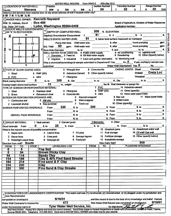
Specific Water Well Detail |
|
|
| Location Info | |||
| Owner: Hayward, Kenneth | Status: Constructed | ||
| Location: T32S, R39W, Sec. 24, SW NE SE | County: Stevens | ||
| Directions: 8 mi W, 7 mi N, 1.25 mi W, .25 mi N | |||
| Latitude: 37.2472439 | Longitude: -101.5044348 | Datum NAD 27 | |
| Latitude: 37.247268 | Longitude: -101.5048706 | Datum NAD 83 | |
| Longitude and latitude calculated by Survey from township-range-section-quarter calls. Only good to within the quarter call accuracy. | |||
| View well on interactive map | |||
| General Info | ||
| Well Depth: 300 ft. | Elevation: ft. | |
| Static Water Level: 91 ft. | Est. Yield: 50 gpm. | |
| Comp. Date: 18-May-2001 | Well Use: Domestic | |
| DWR Applic. #: | Other ID: | |
| Driller Info | ||
| Driller: Destal Tyler Water Well Service | License #: 473 | |
| Scanned Form | View scan |
|
Chemical Sample Submitted?:
Water Well disinfected?: | ||
| Casing Info | ||
| Casing Type:
Casing Joints: |
Diam: in. to ft | |
| Casing height above land surface: in
Casing Weight: lbs/ft Wall thickness or gauge no.: | ||
| Screen and Perforation Info | ||
| Screen Type: | Screen Openings: | |
| Screen-perforated intervals | From: ft to ft | |
| Gravel pack intervals | From: ft to ft | |
| Grout Info | ||
| Grout used: | From: to ft | |
| Source of Possible Contamination | ||
| Source: | ||
| Direction from well: | Distance: ft | |
| Lithologic Log
(Log data entered by KGS.) | ||
| From: 0 ft. to 5 ft. | top soil | |
| From: 5 ft. to 54 ft. | brown sticky clay | |
| From: 54 ft. to 114 ft. | sandy clay | |
| From: 114 ft. to 194 ft. | clay and 40% fine sand streaks | |
| From: 194 ft. to 214 ft. | fine sand and 5-foot clay | |
| From: 214 ft. to 220 ft. | clay | |
| From: 220 ft. to 300 ft. | fine sand and clay streaks | |