|
|
|
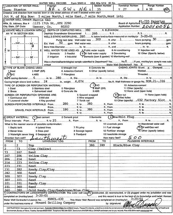
Specific Water Well Detail |
|
|
| Location Info | |||
| Owner: Harris Oil and Gas | Status: Constructed | ||
| Location: T27S, R39W, Sec. 35, NE SW NE | County: Stanton | ||
| Directions: Jct N of Big Bow: 5 mi N, 1 mi E, .7 mi N, W into site | |||
| Latitude: 37.659338 | Longitude: -101.5499463 | Datum NAD 27 | |
| Latitude: 37.6593547 | Longitude: -101.5503947 | Datum NAD 83 | |
| Longitude and latitude calculated by Survey from township-range-section-quarter calls. Only good to within the quarter call accuracy. | |||
| View well on interactive map | |||
| General Info | ||
| Well Depth: 380 ft. | Elevation: ft. | |
| Static Water Level: 260 ft. | Est. Yield: 50 gpm. | |
| Comp. Date: 20-Mar-2001 | Well Use: Oil Field Water Supply | |
| DWR Applic. #: 20010056 | Other ID: Feiertag 1-735 | |
| Links | |
| No Wizard information available. | |
| View info from WIMAS Water Right Data base... | |
| Driller Info | ||
| Driller: Howard Drilling Company AG, LLC | License #: 430 | |
| Scanned Form | View scan |
|
Chemical Sample Submitted?:
Water Well disinfected?: | ||
| Casing Info | ||
| Casing Type:
Casing Joints: |
Diam: in. to ft | |
| Casing height above land surface: in
Casing Weight: lbs/ft Wall thickness or gauge no.: | ||
| Screen and Perforation Info | ||
| Screen Type: | Screen Openings: | |
| Screen-perforated intervals | From: ft to ft | |
| Gravel pack intervals | From: ft to ft | |
| Grout Info | ||
| Grout used: | From: to ft | |
| Source of Possible Contamination | ||
| Source: | ||
| Direction from well: | Distance: ft | |
| Lithologic Log
(Log data entered by KGS.) | ||
| From: 0 ft. to 2 ft. | top | |
| From: 2 ft. to 73 ft. | clay (yellow) | |
| From: 73 ft. to 167 ft. | sand | |
| From: 167 ft. to 206 ft. | yellow clay | |
| From: 206 ft. to 214 ft. | sand | |
| From: 214 ft. to 223 ft. | yellow clay | |
| From: 223 ft. to 231 ft. | sand | |
| From: 231 ft. to 282 ft. | sandy clay/clay | |
| From: 282 ft. to 300 ft. | sand | |
| From: 300 ft. to 307 ft. | sandy clay | |
| From: 307 ft. to 321 ft. | sand | |
| From: 321 ft. to 331 ft. | sandy clay | |
| From: 331 ft. to 360 ft. | sand | |
| From: 360 ft. to 380 ft. | gold sandy clay/sandstone/blue clay | |
| From: 380 ft. to 390 ft. | black/blue clay | |