|
|
|
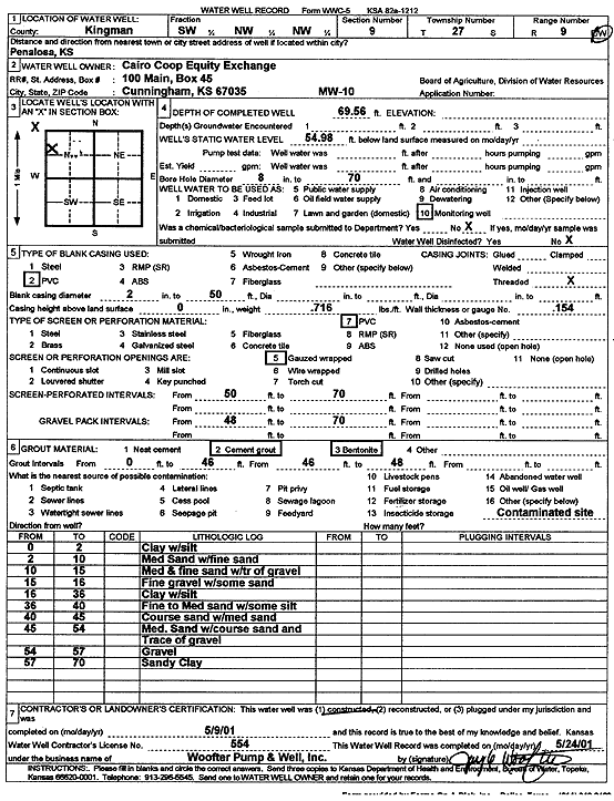
Specific Water Well Detail |
|
|
| Location Info | |||
| Owner: Cairo Coop Equity Exchange | Status: Constructed | ||
| Location: T27S, R9W, Sec. 9, SW NW NW | County: Kingman | ||
| Directions: Penalosa | |||
| Latitude: 37.7150776 | Longitude: -98.3178192 | Datum NAD 27 | |
| Latitude: 37.7150945 | Longitude: -98.3181682 | Datum NAD 83 | |
| Longitude and latitude calculated by Survey from township-range-section-quarter calls. Only good to within the quarter call accuracy. | |||
| View well on interactive map | |||
| General Info | ||
| Well Depth: 69.56 ft. | Elevation: ft. | |
| Static Water Level: 54.98 ft. | Est. Yield: gpm. | |
| Comp. Date: 09-May-2001 | Well Use: Monitoring well/observation/piezometer | |
| DWR Applic. #: | Other ID: MW 10 | |
| Driller Info | ||
| Driller: Jay C. Woofter Pump & Well, Inc. | License #: 554 | |
| Scanned Form | View scan |
|
Chemical Sample Submitted?:
Water Well disinfected?: | ||
| Casing Info | ||
| Casing Type:
Casing Joints: |
Diam: in. to ft | |
| Casing height above land surface: in
Casing Weight: lbs/ft Wall thickness or gauge no.: | ||
| Screen and Perforation Info | ||
| Screen Type: | Screen Openings: | |
| Screen-perforated intervals | From: ft to ft | |
| Gravel pack intervals | From: ft to ft | |
| Grout Info | ||
| Grout used: | From: to ft | |
| Source of Possible Contamination | ||
| Source: | ||
| Direction from well: | Distance: ft | |
| Lithologic Log
(Log data entered by KGS.) | ||
| From: 0 ft. to 2 ft. | clay with silt | |
| From: 2 ft. to 10 ft. | medium sand with fine sand | |
| From: 10 ft. to 15 ft. | medium and fine sand with trace of gravel | |
| From: 15 ft. to 16 ft. | fine gravel with some sand | |
| From: 16 ft. to 35 ft. | clay with silt | |
| From: 35 ft. to 40 ft. | fine to medium sand with some silt | |
| From: 40 ft. to 45 ft. | coarse sand with medium sand | |
| From: 45 ft. to 54 ft. | medium sand with coarse sand and trace of gravel | |
| From: 54 ft. to 57 ft. | gravel | |
| From: 57 ft. to 70 ft. | sandy clay | |