|
|
|
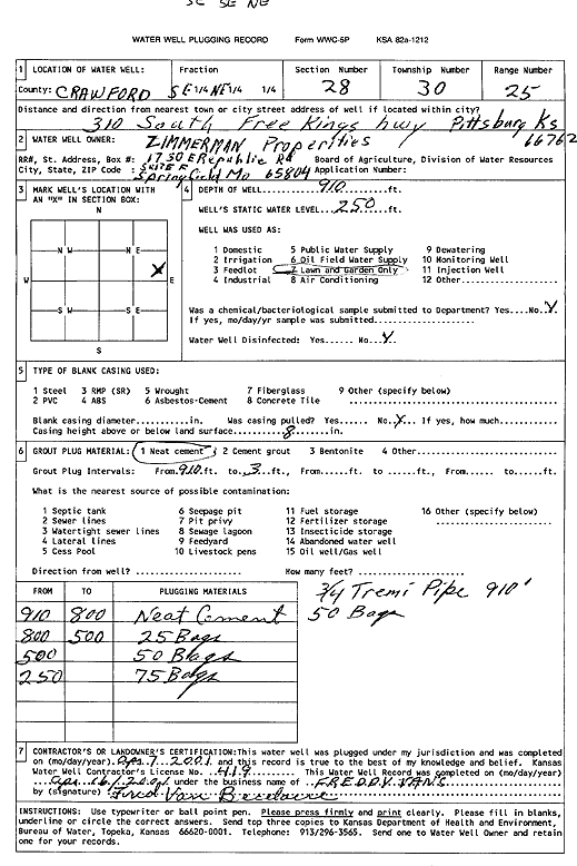
Specific Water Well Detail |
|
|
| Location Info | |||
| Owner: Zimmerman Properties | Status: Plugged | ||
| Location: T30S, R25E, Sec. 28, SE SE NE | County: Crawford | ||
| Directions: 310 S Free Kings Hwy, Pittsburg | |||
| Latitude: 37.4045996 | Longitude: -94.6694863 | Datum NAD 27 | |
| Latitude: 37.4046507 | Longitude: -94.6697228 | Datum NAD 83 | |
| Longitude and latitude calculated by Survey from township-range-section-quarter calls. Only good to within the quarter call accuracy. | |||
| View well on interactive map | |||
| General Info | ||
| Well Depth: 910 ft. | Elevation: ft. | |
| Static Water Level: 250 ft. | Est. Yield: gpm. | |
| Comp. Date: 07-Apr-2001 | Well Use: Domestic, Lawn and Garden | |
| DWR Applic. #: | Other ID: | |
| Driller Info | ||
| Driller: Freddy Vans | License #: 419 | |
| Scanned Form | View scan |
| Casing Info | ||
|
Casing Type:
Diam: in. Casing height above land surface: in | ||
| Grout Info | ||
| Grout used: | From: to ft | |
| Source of Possible Contamination | ||
| Source: | ||
| Direction from well: | Distance: ft | |