|
|
|
Specific Water Well Detail |
|
|
| Location Info | |||
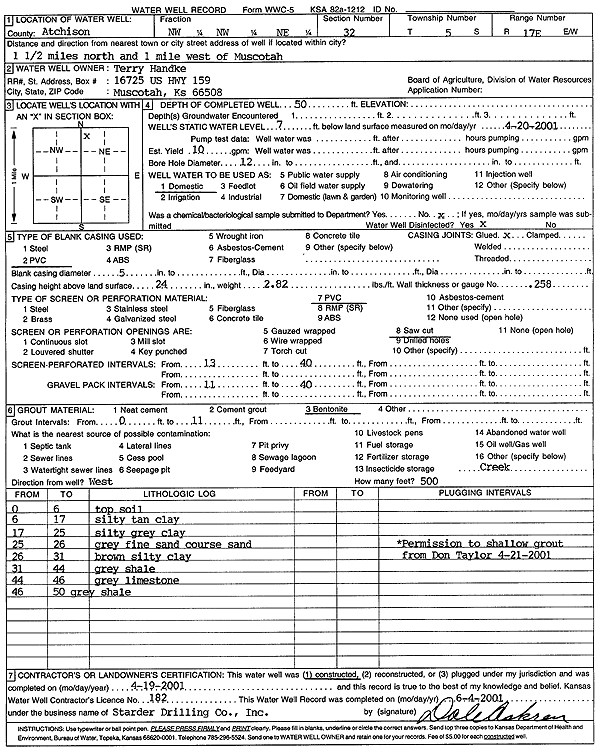
| Owner: Handke, Terry | Status: Constructed | ||
| Location: T5S, R17E, Sec. 32, NW NW NE | County: Atchison | ||
| Directions: from Muscotah: 1.5 mi N, 1 mi W | |||
| Latitude: 39.5793107 | Longitude: -95.5348712 | Datum NAD 27 | |
| Latitude: 39.5793104 | Longitude: -95.5351281 | Datum NAD 83 | |
| Longitude and latitude calculated by Survey from township-range-section-quarter calls. Only good to within the quarter call accuracy. | |||
| View well on interactive map | |||
| General Info | ||
| Well Depth: 50 ft. | Elevation: ft. | |
| Static Water Level: 7 ft. | Est. Yield: 10 gpm. | |
| Comp. Date: 19-Apr-2001 | Well Use: Domestic | |
| DWR Applic. #: | Other ID: | |
| Driller Info | ||
| Driller: Strader Drilling Co., Inc. | License #: 182 | |
| Scanned Form | View scan |
|
Chemical Sample Submitted?:
Water Well disinfected?: | ||
| Casing Info | ||
| Casing Type:
Casing Joints: |
Diam: in. to ft | |
| Casing height above land surface: in
Casing Weight: lbs/ft Wall thickness or gauge no.: | ||
| Screen and Perforation Info | ||
| Screen Type: | Screen Openings: | |
| Screen-perforated intervals | From: ft to ft | |
| Gravel pack intervals | From: ft to ft | |
| Grout Info | ||
| Grout used: | From: to ft | |
| Source of Possible Contamination | ||
| Source: | ||
| Direction from well: | Distance: ft | |
| Lithologic Log
(Log data entered by KGS.) | ||
| From: 0 ft. to 6 ft. | Topsoil | |
| From: 6 ft. to 17 ft. | Silty tan clay | |
| From: 17 ft. to 25 ft. | Silty gray clay | |
| From: 25 ft. to 26 ft. | Gray fine sand, coarse sand | |
| From: 26 ft. to 31 ft. | Brown silty clay | |
| From: 31 ft. to 44 ft. | Gray shale | |
| From: 44 ft. to 46 ft. | Gray limestone | |
| From: 46 ft. to 50 ft. | Gray shale | |