|
|
|
Specific Water Well Detail |
|
|
| Location Info | |||
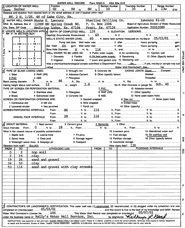
| Owner: Sterling Drilling Co./Monte E. Lawrenz | Status: Constructed | ||
| Location: T30S, R13W, Sec. 10, SE SW SW | County: Barber | ||
| Directions: from Lake City, 4 mi W, 2 mi N, .5 mi E, 4 mi N | |||
| Latitude: 37.4425737 | Longitude: -98.7347893 | Datum NAD 27 | |
| Latitude: 37.4425943 | Longitude: -98.7351581 | Datum NAD 83 | |
| Longitude and latitude calculated by Survey from township-range-section-quarter calls. Only good to within the quarter call accuracy. | |||
| View well on interactive map | |||
| General Info | ||
| Well Depth: 116 ft. | Elevation: ft. | |
| Static Water Level: 60 ft. | Est. Yield: 60 gpm. | |
| Comp. Date: 03-May-2001 | Well Use: Oil Field Water Supply | |
| DWR Applic. #: 20010089 | Other ID: Lawrenz 1-10 | |
| Links | |
| No Wizard information available. | |
| View info from WIMAS Water Right Data base... | |
| Driller Info | ||
| Driller: Kelly's Water Well Service, Inc. | License #: 186 | |
| Scanned Form | View scan |
|
Chemical Sample Submitted?:
Water Well disinfected?: | ||
| Casing Info | ||
| Casing Type:
Casing Joints: |
Diam: in. to ft | |
| Casing height above land surface: in
Casing Weight: lbs/ft Wall thickness or gauge no.: | ||
| Screen and Perforation Info | ||
| Screen Type: | Screen Openings: | |
| Screen-perforated intervals | From: ft to ft | |
| Gravel pack intervals | From: ft to ft | |
| Grout Info | ||
| Grout used: | From: to ft | |
| Source of Possible Contamination | ||
| Source: | ||
| Direction from well: | Distance: ft | |
| Lithologic Log
(Log data entered by KGS.) | ||
| From: 0 ft. to 2 ft. | Topsoil | |
| From: 2 ft. to 19 ft. | Clay | |
| From: 19 ft. to 24 ft. | Sand and gravel | |
| From: 24 ft. to 52 ft. | Clay | |
| From: 52 ft. to 116 ft. | Sand and gravel with clay streaks | |