|
|
|
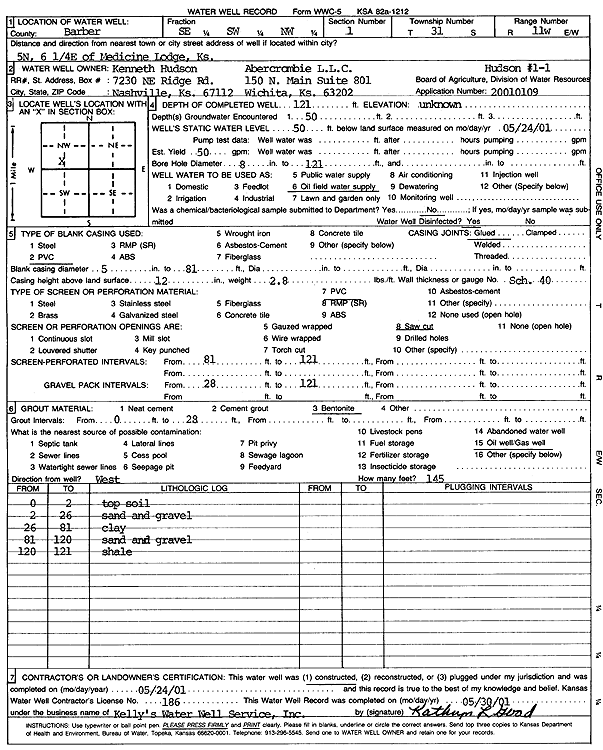
Specific Water Well Detail |
|
|
| Location Info | |||
| Owner: Abercrombie LLC/Kenneth Hudson | Status: Constructed | ||
| Location: T31S, R11W, Sec. 1, SE SW NW | County: Barber | ||
| Directions: From Medicine Lodge, 5 mi N and 6.25 mi E | |||
| Latitude: 37.3776087 | Longitude: -98.4733322 | Datum NAD 27 | |
| Latitude: 37.3776296 | Longitude: -98.4736892 | Datum NAD 83 | |
| Longitude and latitude calculated by Survey from township-range-section-quarter calls. Only good to within the quarter call accuracy. | |||
| View well on interactive map | |||
| General Info | ||
| Well Depth: 121 ft. | Elevation: ft. | |
| Static Water Level: 50 ft. | Est. Yield: 50 gpm. | |
| Comp. Date: 24-May-2001 | Well Use: Oil Field Water Supply | |
| DWR Applic. #: 20010109 | Other ID: Hudson 1-1 | |
| Links | |
| No Wizard information available. | |
| View info from WIMAS Water Right Data base... | |
| Driller Info | ||
| Driller: Kelly's Water Well Service, Inc. | License #: 186 | |
| Scanned Form | View scan |
|
Chemical Sample Submitted?:
Water Well disinfected?: | ||
| Casing Info | ||
| Casing Type:
Casing Joints: |
Diam: in. to ft | |
| Casing height above land surface: in
Casing Weight: lbs/ft Wall thickness or gauge no.: | ||
| Screen and Perforation Info | ||
| Screen Type: | Screen Openings: | |
| Screen-perforated intervals | From: ft to ft | |
| Gravel pack intervals | From: ft to ft | |
| Grout Info | ||
| Grout used: | From: to ft | |
| Source of Possible Contamination | ||
| Source: | ||
| Direction from well: | Distance: ft | |
| Lithologic Log
(Log data entered by KGS.) | ||
| From: 0 ft. to 2 ft. | Topsoil | |
| From: 2 ft. to 26 ft. | Sand and gravel | |
| From: 26 ft. to 81 ft. | Clay | |
| From: 81 ft. to 120 ft. | Sand and gravel | |
| From: 120 ft. to 121 ft. | Shale | |