|
|
|
Specific Water Well Detail |
|
|
| Location Info | |||
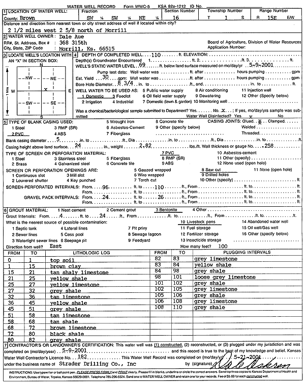
| Owner: Aue, Dale | Status: Constructed | ||
| Location: T1S, R15E, Sec. 16, SW SW NE | County: Brown | ||
| Directions: from Morrill, 2.5 mi W and 2.63 mi N | |||
| Latitude: 39.9660656 | Longitude: -95.739249 | Datum NAD 27 | |
| Latitude: 39.9660668 | Longitude: -95.7395138 | Datum NAD 83 | |
| Longitude and latitude calculated by Survey from township-range-section-quarter calls. Only good to within the quarter call accuracy. | |||
| View well on interactive map | |||
| General Info | ||
| Well Depth: 110 ft. | Elevation: ft. | |
| Static Water Level: 69 ft. | Est. Yield: 30 gpm. | |
| Comp. Date: 09-May-2001 | Well Use: Domestic | |
| DWR Applic. #: | Other ID: | |
| Driller Info | ||
| Driller: Strader Drilling Co., Inc. | License #: 182 | |
| Scanned Form | View scan |
|
Chemical Sample Submitted?:
Water Well disinfected?: | ||
| Casing Info | ||
| Casing Type:
Casing Joints: |
Diam: in. to ft | |
| Casing height above land surface: in
Casing Weight: lbs/ft Wall thickness or gauge no.: | ||
| Screen and Perforation Info | ||
| Screen Type: | Screen Openings: | |
| Screen-perforated intervals | From: ft to ft | |
| Gravel pack intervals | From: ft to ft | |
| Grout Info | ||
| Grout used: | From: to ft | |
| Source of Possible Contamination | ||
| Source: | ||
| Direction from well: | Distance: ft | |
| Lithologic Log
(Log data entered by KGS.) | ||
| From: 0 ft. to 1 ft. | Topsoil | |
| From: 1 ft. to 15 ft. | Brown clay | |
| From: 15 ft. to 21 ft. | Tan shaley limestone | |
| From: 21 ft. to 25 ft. | Yellow shale | |
| From: 25 ft. to 27 ft. | Yellow limestone | |
| From: 27 ft. to 32 ft. | Gray shale | |
| From: 32 ft. to 36 ft. | Tan limestone | |
| From: 36 ft. to 45 ft. | Yellow shale | |
| From: 45 ft. to 51 ft. | Gray shale | |
| From: 51 ft. to 58 ft. | Tan limestone | |
| From: 58 ft. to 68 ft. | Tan shale | |
| From: 68 ft. to 72 ft. | Brown limestone | |
| From: 72 ft. to 80 ft. | Black shale | |
| From: 80 ft. to 82 ft. | Gray shale | |
| From: 82 ft. to 83 ft. | Gray limestone | |
| From: 83 ft. to 84 ft. | Yellow shale | |
| From: 84 ft. to 98 ft. | Gray shale | |
| From: 98 ft. to 101 ft. | Loose gray limestone | |
| From: 101 ft. to 102 ft. | Gray shale | |
| From: 102 ft. to 105 ft. | Gray limestone | |
| From: 105 ft. to 106 ft. | Gray shale | |
| From: 106 ft. to 108 ft. | Gray limestone | |
| From: 108 ft. to 110 ft. | Gray shale | |