|
|
|
Specific Water Well Detail |
|
|
| Location Info | |||
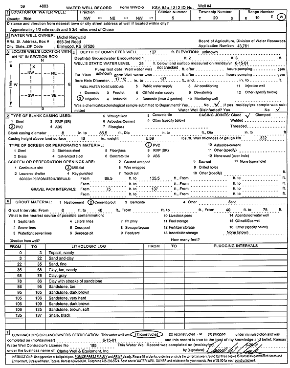
| Owner: Ringwald, Michel | Status: Constructed | ||
| Location: T20S, R10W, Sec. 5, NW NE NW | County: Rice | ||
| Directions: from Chase: .5 mi S, 5.75 mi W | |||
| Latitude: 38.3466319 | Longitude: -98.4555568 | Datum NAD 27 | |
| Latitude: 38.3466436 | Longitude: -98.4559064 | Datum NAD 83 | |
| Longitude and latitude calculated by Survey from township-range-section-quarter calls. Only good to within the quarter call accuracy. | |||
| View well on interactive map | |||
| General Info | ||
| Well Depth: 137 ft. | Elevation: ft. | |
| Static Water Level: 24 ft. | Est. Yield: gpm. | |
| Comp. Date: 15-Jun-2001 | Well Use: Irrigation | |
| DWR Applic. #: 43781 | Other ID: Well 4 | |
| Links | |
| No Wizard information available. | |
| View info from WIMAS Water Right Data base... | |
| Driller Info | ||
| Driller: Clarke Well and Equipment, Inc. | License #: 185 | |
| Scanned Form | View scan |
|
Chemical Sample Submitted?:
Water Well disinfected?: | ||
| Casing Info | ||
| Casing Type:
Casing Joints: |
Diam: in. to ft | |
| Casing height above land surface: in
Casing Weight: lbs/ft Wall thickness or gauge no.: | ||
| Screen and Perforation Info | ||
| Screen Type: | Screen Openings: | |
| Screen-perforated intervals | From: ft to ft | |
| Gravel pack intervals | From: ft to ft | |
| Grout Info | ||
| Grout used: | From: to ft | |
| Source of Possible Contamination | ||
| Source: | ||
| Direction from well: | Distance: ft | |
| Lithologic Log
(Log data entered by KGS.) | ||
| From: 0 ft. to 3 ft. | sandy top soil | |
| From: 3 ft. to 22 ft. | sand and clay | |
| From: 22 ft. to 35 ft. | fine sand | |
| From: 35 ft. to 68 ft. | sandy clay, tan | |
| From: 68 ft. to 78 ft. | clay, gray | |
| From: 78 ft. to 86 ft. | clay with streaks of sandstone | |
| From: 86 ft. to 95 ft. | sandstone, tan | |
| From: 95 ft. to 105 ft. | sandstone, dark brown | |
| From: 105 ft. to 106 ft. | sandstone, very hard | |
| From: 106 ft. to 109 ft. | sandstone, dark brown | |
| From: 109 ft. to 135 ft. | sandstone, brown, soft | |
| From: 135 ft. to 137 ft. | shale, black | |