|
|
|
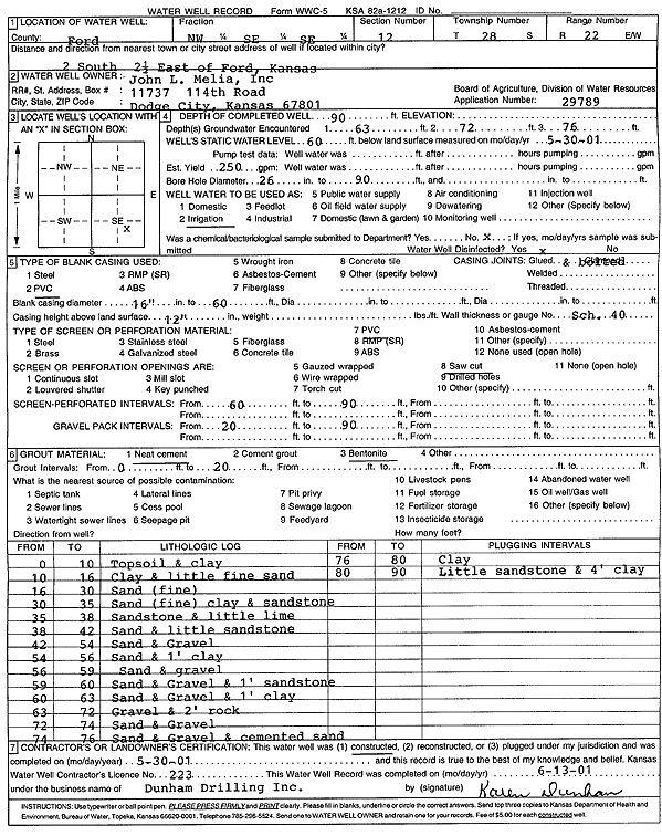
Specific Water Well Detail |
|
|
| Location Info | |||
| Owner: Melia, John L, Inc | Status: Constructed | ||
| Location: T28S, R22W, Sec. 12, NW SE SE | County: Ford | ||
| Directions: from Ford: 2 mi S, 2.5 mi E | |||
| Latitude: 37.6188593 | Longitude: -99.6705424 | Datum NAD 27 | |
| Latitude: 37.6188795 | Longitude: -99.6709448 | Datum NAD 83 | |
| Longitude and latitude calculated by Survey from township-range-section-quarter calls. Only good to within the quarter call accuracy. | |||
| View well on interactive map | |||
| General Info | ||
| Well Depth: 90 ft. | Elevation: ft. | |
| Static Water Level: 60 ft. | Est. Yield: 250 gpm. | |
| Comp. Date: 30-May-2001 | Well Use: Irrigation | |
| DWR Applic. #: 29789 | Other ID: | |
| Links | |
| No Wizard information available. | |
| View info from WIMAS Water Right Data base... | |
| Driller Info | ||
| Driller: Donald R. Dunham Drilling, Inc. | License #: 223 | |
| Scanned Form | View scan |
|
Chemical Sample Submitted?:
Water Well disinfected?: | ||
| Casing Info | ||
| Casing Type:
Casing Joints: |
Diam: in. to ft | |
| Casing height above land surface: in
Casing Weight: lbs/ft Wall thickness or gauge no.: | ||
| Screen and Perforation Info | ||
| Screen Type: | Screen Openings: | |
| Screen-perforated intervals | From: ft to ft | |
| Gravel pack intervals | From: ft to ft | |
| Grout Info | ||
| Grout used: | From: to ft | |
| Source of Possible Contamination | ||
| Source: | ||
| Direction from well: | Distance: ft | |
| Lithologic Log
(Log data entered by KGS.) | ||
| From: 0 ft. to 10 ft. | topsoil and clay | |
| From: 10 ft. to 16 ft. | clay and little fine sand | |
| From: 16 ft. to 30 ft. | sand (fine) | |
| From: 30 ft. to 35 ft. | sand (fine) clay and sandstone | |
| From: 35 ft. to 38 ft. | sandstone and little lime | |
| From: 38 ft. to 42 ft. | sand and little sandstone | |
| From: 42 ft. to 54 ft. | sand and gravel | |
| From: 54 ft. to 56 ft. | sand and 1 foot clay | |
| From: 56 ft. to 59 ft. | sand and gravel | |
| From: 59 ft. to 60 ft. | sand and gravel and 1 foot sandstone | |
| From: 60 ft. to 63 ft. | sand and gravel and 1 foot clay | |
| From: 63 ft. to 72 ft. | gravel and 2 feet rock | |
| From: 72 ft. to 74 ft. | sand and gravel | |
| From: 74 ft. to 76 ft. | sand and gravel and cemented sand | |
| From: 76 ft. to 80 ft. | clay | |
| From: 80 ft. to 90 ft. | little sandstone and 4 feet clay | |