|
|
|
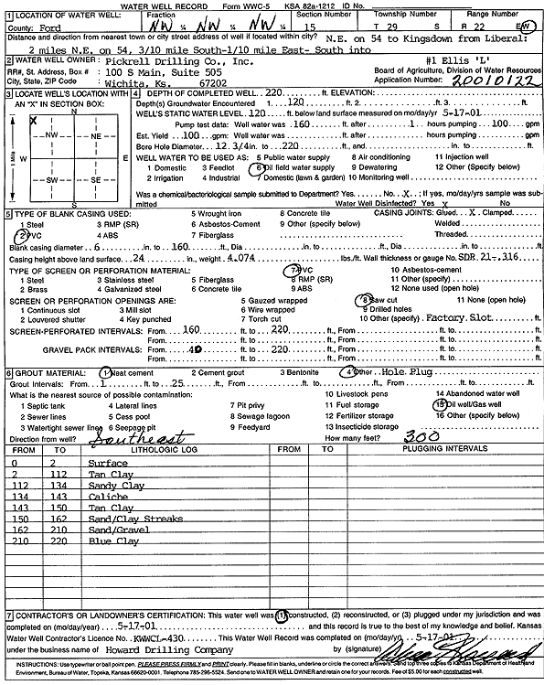
Specific Water Well Detail |
|
|
| Location Info | |||
| Owner: Pickrell Drilling Co. | Status: Constructed | ||
| Location: T29S, R22W, Sec. 15, NW NW NW | County: Ford | ||
| Directions: NE on Hwy 54 to Kingsdown from Liberal. 2 mi NE on 54, .3 mi S, .1 mi E, S into site | |||
| Latitude: 37.5258631 | Longitude: -99.7194233 | Datum NAD 27 | |
| Latitude: 37.5258843 | Longitude: -99.7198273 | Datum NAD 83 | |
| Longitude and latitude calculated by Survey from township-range-section-quarter calls. Only good to within the quarter call accuracy. | |||
| View well on interactive map | |||
| General Info | ||
| Well Depth: 220 ft. | Elevation: ft. | |
| Static Water Level: 120 ft. | Est. Yield: 100 gpm. | |
| Comp. Date: 17-May-2001 | Well Use: Oil Field Water Supply | |
| DWR Applic. #: 20010122 | Other ID: Ellis 'L' 1 | |
| Links | |
| No Wizard information available. | |
| View info from WIMAS Water Right Data base... | |
| Driller Info | ||
| Driller: Howard Drilling Company AG, LLC | License #: 430 | |
| Scanned Form | View scan |
|
Chemical Sample Submitted?:
Water Well disinfected?: | ||
| Casing Info | ||
| Casing Type:
Casing Joints: |
Diam: in. to ft | |
| Casing height above land surface: in
Casing Weight: lbs/ft Wall thickness or gauge no.: | ||
| Screen and Perforation Info | ||
| Screen Type: | Screen Openings: | |
| Screen-perforated intervals | From: ft to ft | |
| Gravel pack intervals | From: ft to ft | |
| Grout Info | ||
| Grout used: | From: to ft | |
| Source of Possible Contamination | ||
| Source: | ||
| Direction from well: | Distance: ft | |
| Lithologic Log
(Log data entered by KGS.) | ||
| From: 0 ft. to 2 ft. | surface | |
| From: 2 ft. to 112 ft. | tan clay | |
| From: 112 ft. to 134 ft. | sandy clay | |
| From: 134 ft. to 143 ft. | caliche | |
| From: 143 ft. to 150 ft. | tan clay | |
| From: 150 ft. to 162 ft. | sand/clay streaks | |
| From: 162 ft. to 210 ft. | sand/gravel | |
| From: 210 ft. to 220 ft. | blue clay | |