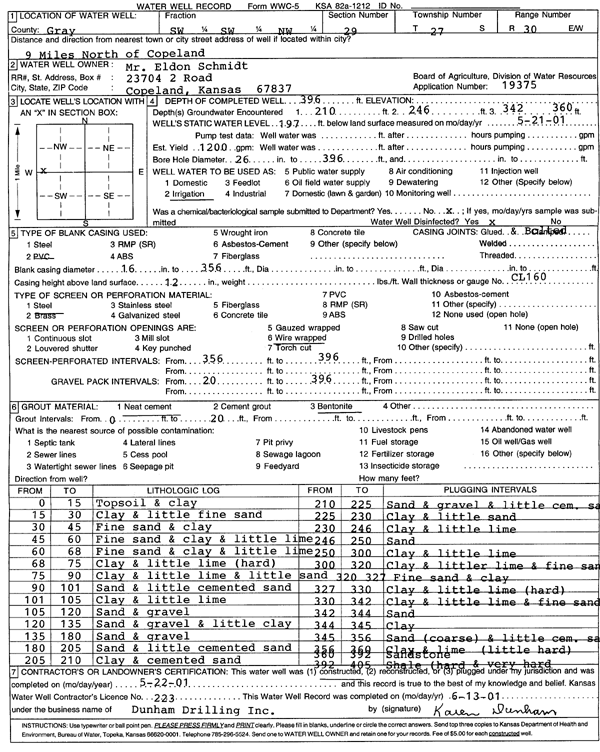
Lithologic Log
(Log data entered by KGS.) |
| |
From: 0 ft. to 15 ft. |
Topsoil and clay |
| |
From: 15 ft. to 30 ft. |
Clay and little fine sand |
| |
From: 30 ft. to 45 ft. |
Fine sand and clay |
| |
From: 45 ft. to 60 ft. |
Fine sand and clay and little lime |
| |
From: 60 ft. to 68 ft. |
Fine sand and clay and little lime |
| |
From: 68 ft. to 75 ft. |
Clay and little lime (hard) |
| |
From: 75 ft. to 90 ft. |
Clay and little lime and little sand |
| |
From: 90 ft. to 101 ft. |
Sand and little cemented sand |
| |
From: 101 ft. to 105 ft. |
Clay and little lime |
| |
From: 105 ft. to 120 ft. |
Sand and gravel |
| |
From: 120 ft. to 135 ft. |
Sand and gravel and little clay |
| |
From: 135 ft. to 180 ft. |
Sand and gravel |
| |
From: 180 ft. to 205 ft. |
Sand and little cemented sand |
| |
From: 205 ft. to 210 ft. |
Clay and cemented sand |
| |
From: 210 ft. to 225 ft. |
Sand and gravel and little cemented sand |
| |
From: 225 ft. to 230 ft. |
Clay and little sand |
| |
From: 230 ft. to 246 ft. |
Clay and little lime |
| |
From: 246 ft. to 250 ft. |
Sand |
| |
From: 250 ft. to 300 ft. |
Clay and little lime |
| |
From: 300 ft. to 320 ft. |
Clay and little lime and fine sand |
| |
From: 320 ft. to 327 ft. |
Fine sand and clay |
| |
From: 327 ft. to 330 ft. |
Clay and lime (hard) |
| |
From: 330 ft. to 342 ft. |
Clay and little lime and fine sand |
| |
From: 342 ft. to 344 ft. |
Sand |
| |
From: 344 ft. to 345 ft. |
Clay |
| |
From: 345 ft. to 356 ft. |
Sand (coarse) and little cemented sand |
| |
From: 356 ft. to 360 ft. |
Clay and lime (little hard) |
| |
From: 360 ft. to 392 ft. |
Sandstone |
| |
From: 392 ft. to 405 ft. |
Shale (hard and very hard) |