|
|
|
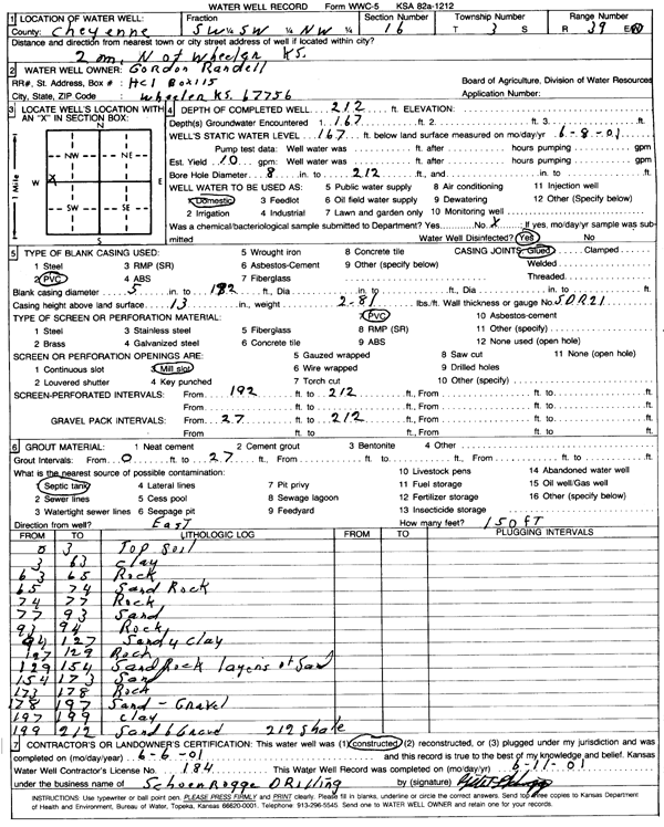
Specific Water Well Detail |
|
|
| Location Info | |||
| Owner: Randell, Gordon | Status: Constructed | ||
| Location: T3S, R39W, Sec. 16, SW SW NW | County: Cheyenne | ||
| Directions: from Wheeler, 2 mi N | |||
| Latitude: 39.7936689 | Longitude: -101.7093081 | Datum NAD 27 | |
| Latitude: 39.7936622 | Longitude: -101.7097575 | Datum NAD 83 | |
| Longitude and latitude calculated by Survey from township-range-section-quarter calls. Only good to within the quarter call accuracy. | |||
| View well on interactive map | |||
| General Info | ||
| Well Depth: 212 ft. | Elevation: ft. | |
| Static Water Level: 167 ft. | Est. Yield: gpm. | |
| Comp. Date: 06-Jun-2001 | Well Use: Domestic | |
| DWR Applic. #: | Other ID: | |
| Links | |
| View info from Wizard Water Level Data base... | |
| No WIMAS information available. | |
| Driller Info | ||
| Driller: Schoenrogge Drilling, Inc. | License #: 184 | |
| Scanned Form | View scan |
|
Chemical Sample Submitted?:
Water Well disinfected?: | ||
| Casing Info | ||
| Casing Type:
Casing Joints: |
Diam: in. to ft | |
| Casing height above land surface: in
Casing Weight: lbs/ft Wall thickness or gauge no.: | ||
| Screen and Perforation Info | ||
| Screen Type: | Screen Openings: | |
| Screen-perforated intervals | From: ft to ft | |
| Gravel pack intervals | From: ft to ft | |
| Grout Info | ||
| Grout used: | From: to ft | |
| Source of Possible Contamination | ||
| Source: | ||
| Direction from well: | Distance: ft | |
| Lithologic Log
(Log data entered by KGS.) | ||
| From: 0 ft. to 3 ft. | Topsoil | |
| From: 3 ft. to 63 ft. | Clay | |
| From: 63 ft. to 65 ft. | Rock | |
| From: 65 ft. to 74 ft. | Sand rock | |
| From: 74 ft. to 77 ft. | Rock | |
| From: 77 ft. to 93 ft. | Sand | |
| From: 93 ft. to 94 ft. | Rock | |
| From: 94 ft. to 127 ft. | Sandy clay | |
| From: 127 ft. to 129 ft. | Rock | |
| From: 129 ft. to 154 ft. | Sand rock, layers of sand | |
| From: 154 ft. to 173 ft. | Sand | |
| From: 173 ft. to 178 ft. | Rock | |
| From: 178 ft. to 197 ft. | Sand, gravel | |
| From: 197 ft. to 199 ft. | Clay | |
| From: 199 ft. to 212 ft. | Sand and gravel | |
| From: 212 ft. to ft. | Shale | |