|
|
|
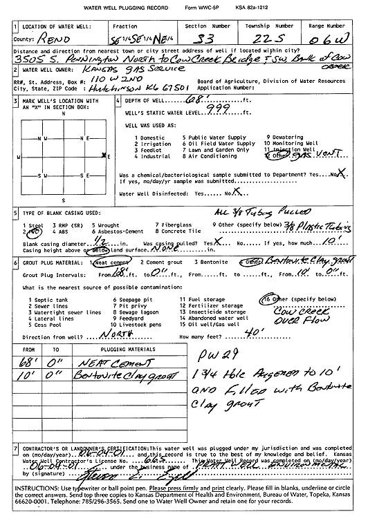
Specific Water Well Detail |
|
|
| Location Info | |||
| Owner: Kansas Gas Service | Status: Plugged | ||
| Location: T22S, R6W, Sec. 33, SE SE NE | County: Reno | ||
| Directions: 3505 S Pennington, N to Cow Creek bridge and SW bank of Cow Creek | |||
| Latitude: 38.0939632 | Longitude: -97.9787784 | Datum NAD 27 | |
| Latitude: 38.0939743 | Longitude: -97.9791094 | Datum NAD 83 | |
| Longitude and latitude calculated by Survey from township-range-section-quarter calls. Only good to within the quarter call accuracy. | |||
| View well on interactive map | |||
| General Info | ||
| Well Depth: 68 ft. | Elevation: ft. | |
| Static Water Level: ft. | Est. Yield: gpm. | |
| Comp. Date: 04-Jun-2001 | Well Use: Other (gas vent well) | |
| DWR Applic. #: | Other ID: PW 29 | |
| Driller Info | ||
| Driller: Pratt Well Service, Inc. | License #: 665 | |
| Scanned Form | View scan |
| Casing Info | ||
|
Casing Type:
Diam: in. Casing height above land surface: in | ||
| Grout Info | ||
| Grout used: | From: to ft | |
| Source of Possible Contamination | ||
| Source: | ||
| Direction from well: | Distance: ft | |