|
|
|
Specific Water Well Detail |
|
|
| Location Info | |||
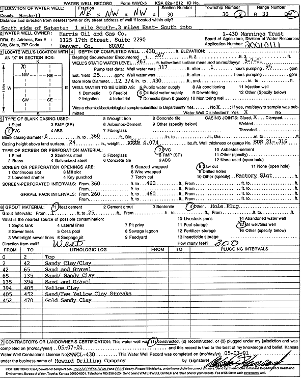
| Owner: Harris Oil and Gas Co. | Status: Constructed | ||
| Location: T30S, R33W, Sec. 30, NE NW NW | County: Haskell | ||
| Directions: from S side of Satanta: 1 mi S, 0.3 mi E, S into site | |||
| Latitude: 37.4159426 | Longitude: -100.9763171 | Datum NAD 27 | |
| Latitude: 37.415967 | Longitude: -100.9767612 | Datum NAD 83 | |
| Longitude and latitude calculated by Survey from township-range-section-quarter calls. Only good to within the quarter call accuracy. | |||
| View well on interactive map | |||
| General Info | ||
| Well Depth: 430 ft. | Elevation: ft. | |
| Static Water Level: 267 ft. | Est. Yield: gpm. | |
| Comp. Date: 07-May-2001 | Well Use: Oil Field Water Supply | |
| DWR Applic. #: 20010111 | Other ID: Nanninga Trust 1-430 | |
| Links | |
| No Wizard information available. | |
| View info from WIMAS Water Right Data base... | |
| Driller Info | ||
| Driller: Howard Drilling Company AG, LLC | License #: 430 | |
| Scanned Form | View scan |
|
Chemical Sample Submitted?:
Water Well disinfected?: | ||
| Casing Info | ||
| Casing Type:
Casing Joints: |
Diam: in. to ft | |
| Casing height above land surface: in
Casing Weight: lbs/ft Wall thickness or gauge no.: | ||
| Screen and Perforation Info | ||
| Screen Type: | Screen Openings: | |
| Screen-perforated intervals | From: ft to ft | |
| Gravel pack intervals | From: ft to ft | |
| Grout Info | ||
| Grout used: | From: to ft | |
| Source of Possible Contamination | ||
| Source: | ||
| Direction from well: | Distance: ft | |
| Lithologic Log
(Log data entered by KGS.) | ||
| From: 0 ft. to 2 ft. | top | |
| From: 2 ft. to 42 ft. | sandy clay/clay | |
| From: 42 ft. to 65 ft. | sand and gravel | |
| From: 65 ft. to 135 ft. | sand/sandy clay | |
| From: 135 ft. to 394 ft. | sand and gravel | |
| From: 394 ft. to 405 ft. | yellow clay | |
| From: 405 ft. to 452 ft. | sand/few yellow clay streaks | |
| From: 452 ft. to 470 ft. | gold sandy clay | |