|
|
|
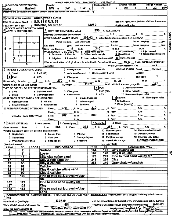
Specific Water Well Detail |
|
|
| Location Info | |||
| Owner: Collingwood Grain, Inc. | Status: Constructed | ||
| Location: T29S, R32W, Sec. 31, NW SW SW | County: Haskell | ||
| Directions: | |||
| Latitude: 37.4776136 | Longitude: -100.8695218 | Datum NAD 27 | |
| Latitude: 37.4776381 | Longitude: -100.869963 | Datum NAD 83 | |
| Longitude and latitude calculated by Survey from township-range-section-quarter calls. Only good to within the quarter call accuracy. | |||
| View well on interactive map | |||
| General Info | ||
| Well Depth: 330 ft. | Elevation: ft. | |
| Static Water Level: 309.6 ft. | Est. Yield: gpm. | |
| Comp. Date: 07-May-2001 | Well Use: Monitoring well/observation/piezometer | |
| DWR Applic. #: | Other ID: MW 2 | |
| Driller Info | ||
| Driller: Jay C. Woofter Pump & Well, Inc. | License #: 554 | |
| Scanned Form | View scan |
|
Chemical Sample Submitted?:
Water Well disinfected?: | ||
| Casing Info | ||
| Casing Type:
Casing Joints: |
Diam: in. to ft | |
| Casing height above land surface: in
Casing Weight: lbs/ft Wall thickness or gauge no.: | ||
| Screen and Perforation Info | ||
| Screen Type: | Screen Openings: | |
| Screen-perforated intervals | From: ft to ft | |
| Gravel pack intervals | From: ft to ft | |
| Grout Info | ||
| Grout used: | From: to ft | |
| Source of Possible Contamination | ||
| Source: | ||
| Direction from well: | Distance: ft | |
| Lithologic Log
(Log data entered by KGS.) | ||
| From: 0 ft. to 2 ft. | surface | |
| From: 2 ft. to 7 ft. | loess | |
| From: 7 ft. to 17 ft. | silty clay with fine sand | |
| From: 17 ft. to 41 ft. | clay and fine sand str | |
| From: 41 ft. to 55 ft. | clay and caliche | |
| From: 55 ft. to 62 ft. | caliche | |
| From: 62 ft. to 68 ft. | clay and caliche with fine sand | |
| From: 68 ft. to 90 ft. | clay and caliche | |
| From: 90 ft. to 102 ft. | fine to medium sand and gravel with clay str. | |
| From: 102 ft. to 127 ft. | fine to medium sand with clay str | |
| From: 127 ft. to 132 ft. | clay | |
| From: 132 ft. to 154 ft. | fine to medium sand and gravel with clay lens | |
| From: 154 ft. to 162 ft. | clay with sand str | |
| From: 162 ft. to 178 ft. | clay and caliche | |
| From: 178 ft. to 249 ft. | fine to medium sand with clay str | |
| From: 249 ft. to 255 ft. | clay | |
| From: 255 ft. to 340 ft. | gray shale with sand str | |