|
|
|
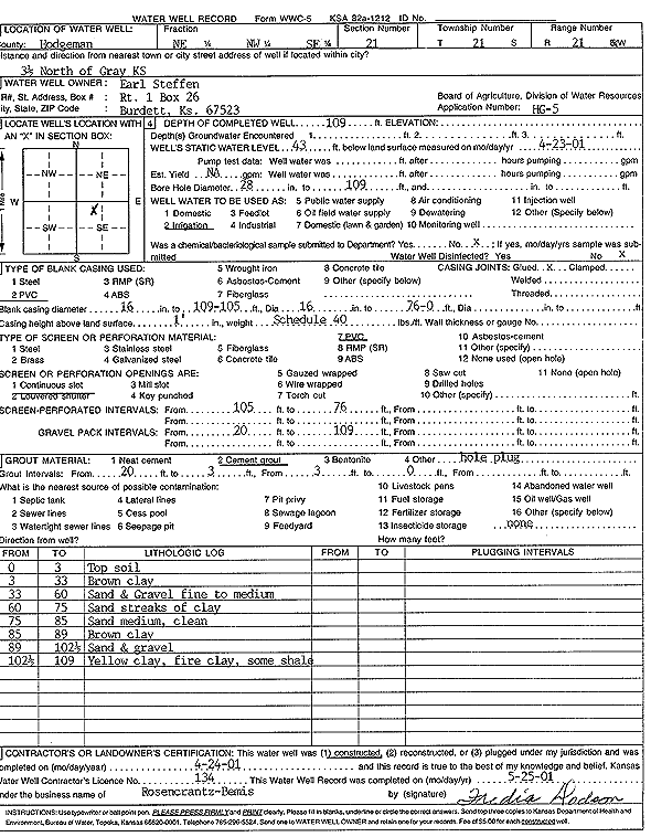
Specific Water Well Detail |
|
|
| Location Info | |||
| Owner: Steffen, Earl | Status: Constructed | ||
| Location: T21S, R21W, Sec. 21, NE NW SE | County: Hodgeman | ||
| Directions: from Gray: 3.5 mi N | |||
| Latitude: 38.2102516 | Longitude: -99.6306187 | Datum NAD 27 | |
| Latitude: 38.2102677 | Longitude: -99.6310168 | Datum NAD 83 | |
| Longitude and latitude calculated by Survey from township-range-section-quarter calls. Only good to within the quarter call accuracy. | |||
| View well on interactive map | |||
| General Info | ||
| Well Depth: 109 ft. | Elevation: ft. | |
| Static Water Level: 43 ft. | Est. Yield: gpm. | |
| Comp. Date: 24-Apr-2001 | Well Use: Irrigation | |
| DWR Applic. #: HG 5 | Other ID: | |
| Links | |
| No Wizard information available. | |
| View info from WIMAS Water Right Data base... | |
| Driller Info | ||
| Driller: Rosencrantz-Bemis Enterprises, Inc. | License #: 134 | |
| Scanned Form | View scan |
|
Chemical Sample Submitted?:
Water Well disinfected?: | ||
| Casing Info | ||
| Casing Type:
Casing Joints: |
Diam: in. to ft | |
| Casing height above land surface: in
Casing Weight: lbs/ft Wall thickness or gauge no.: | ||
| Screen and Perforation Info | ||
| Screen Type: | Screen Openings: | |
| Screen-perforated intervals | From: ft to ft | |
| Gravel pack intervals | From: ft to ft | |
| Grout Info | ||
| Grout used: | From: to ft | |
| Source of Possible Contamination | ||
| Source: | ||
| Direction from well: | Distance: ft | |
| Lithologic Log
(Log data entered by KGS.) | ||
| From: 0 ft. to 3 ft. | top soil | |
| From: 3 ft. to 33 ft. | brown clay | |
| From: 33 ft. to 60 ft. | sand and gravel, fine to medium | |
| From: 60 ft. to 75 ft. | sand with streaks of clay | |
| From: 75 ft. to 85 ft. | sand, medium clay | |
| From: 85 ft. to 89 ft. | brown clay | |
| From: 89 ft. to 102.5 ft. | sand and gravel | |
| From: 102.5 ft. to 109 ft. | yellow clay, fire clay, some shale | |