|
|
|
Specific Water Well Detail |
|
|
| Location Info | |||
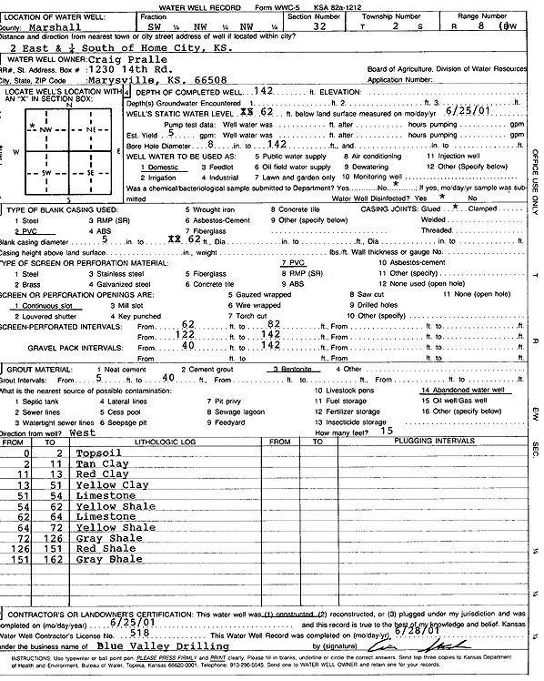
| Owner: Pralle, Craig | Status: Constructed | ||
| Location: T2S, R8E, Sec. 32, SW NW NW | County: Marshall | ||
| Directions: 2 mi E, .25 mi of Home City | |||
| Latitude: 39.8387972 | Longitude: -96.5562468 | Datum NAD 27 | |
| Latitude: 39.8387985 | Longitude: -96.5565422 | Datum NAD 83 | |
| Longitude and latitude calculated by Survey from township-range-section-quarter calls. Only good to within the quarter call accuracy. | |||
| View well on interactive map | |||
| General Info | ||
| Well Depth: 142 ft. | Elevation: ft. | |
| Static Water Level: 62 ft. | Est. Yield: 5 gpm. | |
| Comp. Date: 25-Jun-2001 | Well Use: Domestic | |
| DWR Applic. #: | Other ID: | |
| Driller Info | ||
| Driller: Blue Valley Drilling | License #: 518 | |
| Scanned Form | View scan |
|
Chemical Sample Submitted?:
Water Well disinfected?: | ||
| Casing Info | ||
| Casing Type:
Casing Joints: |
Diam: in. to ft | |
| Casing height above land surface: in
Casing Weight: lbs/ft Wall thickness or gauge no.: | ||
| Screen and Perforation Info | ||
| Screen Type: | Screen Openings: | |
| Screen-perforated intervals | From: ft to ft | |
| Gravel pack intervals | From: ft to ft | |
| Grout Info | ||
| Grout used: | From: to ft | |
| Source of Possible Contamination | ||
| Source: | ||
| Direction from well: | Distance: ft | |
| Lithologic Log
(Log data entered by KGS.) | ||
| From: 0 ft. to 2 ft. | top soil | |
| From: 2 ft. to 11 ft. | tan clay | |
| From: 11 ft. to 13 ft. | red clay | |
| From: 13 ft. to 51 ft. | yellow clay | |
| From: 51 ft. to 54 ft. | limestone | |
| From: 54 ft. to 62 ft. | yellow shale | |
| From: 62 ft. to 64 ft. | limestone | |
| From: 64 ft. to 72 ft. | yellow shale | |
| From: 72 ft. to 126 ft. | gray shale | |
| From: 126 ft. to 151 ft. | red shale | |
| From: 151 ft. to 162 ft. | gray shale | |