|
|
|
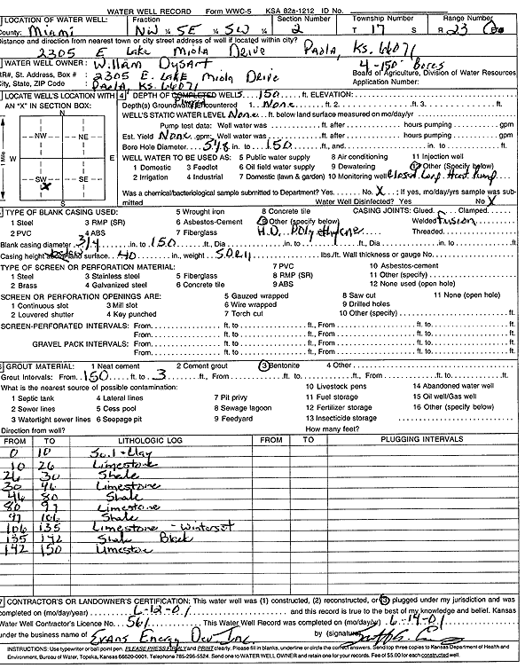
Specific Water Well Detail |
|
|
| Location Info | |||
| Owner: Dysart, William | Status: Constructed | ||
| Location: T17S, R23E, Sec. 2, NW SE SW | County: Miami | ||
| Directions: 2305 East Lake Miola Dr, Paola (four 150-foot bores) | |||
| Latitude: 38.5951772 | Longitude: -94.8391398 | Datum NAD 27 | |
| Latitude: 38.59519 | Longitude: -94.839379 | Datum NAD 83 | |
| Longitude and latitude calculated by Survey from township-range-section-quarter calls. Only good to within the quarter call accuracy. | |||
| View well on interactive map | |||
| General Info | ||
| Well Depth: 150 ft. | Elevation: ft. | |
| Static Water Level: ft. | Est. Yield: gpm. | |
| Comp. Date: 12-Jun-2001 | Well Use: Heat Pump (Closed Loop/Disposal), Geothermal | |
| DWR Applic. #: | Other ID: | |
| Driller Info | ||
| Driller: Evans Energy Development, Inc. | License #: 561 | |
| Scanned Form | View scan |
|
Chemical Sample Submitted?:
Water Well disinfected?: | ||
| Casing Info | ||
| Casing Type:
Casing Joints: |
Diam: in. to ft | |
| Casing height above land surface: in
Casing Weight: lbs/ft Wall thickness or gauge no.: | ||
| Screen and Perforation Info | ||
| Screen Type: | Screen Openings: | |
| Screen-perforated intervals | From: ft to ft | |
| Gravel pack intervals | From: ft to ft | |
| Grout Info | ||
| Grout used: | From: to ft | |
| Source of Possible Contamination | ||
| Source: | ||
| Direction from well: | Distance: ft | |
| Lithologic Log
(Log data entered by KGS.) | ||
| From: 0 ft. to 10 ft. | soil and clay | |
| From: 10 ft. to 26 ft. | limestone | |
| From: 26 ft. to 30 ft. | shale | |
| From: 30 ft. to 46 ft. | limestone | |
| From: 46 ft. to 80 ft. | shale | |
| From: 80 ft. to 97 ft. | limestone | |
| From: 97 ft. to 106 ft. | shale | |
| From: 106 ft. to 135 ft. | limestone (Winterset Ls Mbr) | |
| From: 135 ft. to 142 ft. | shale, black | |
| From: 142 ft. to 150 ft. | limestone | |