|
|
|
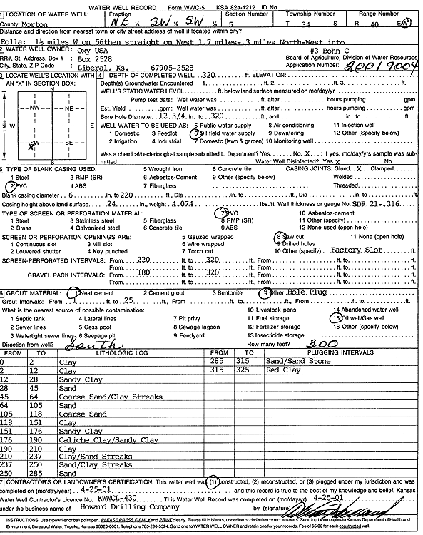
Specific Water Well Detail |
|
|
| Location Info | |||
| Owner: Oxy USA, Inc. | Status: Constructed | ||
| Location: T34S, R40W, Sec. 5, NE SW SW | County: Morton | ||
| Directions: from Rolla: 1.5 mi W on 56, straight W 1.7 mi, .3 mi NW into site | |||
| Latitude: 37.1153907 | Longitude: -101.6966758 | Datum NAD 27 | |
| Latitude: 37.1154156 | Longitude: -101.697116 | Datum NAD 83 | |
| Longitude and latitude calculated by Survey from township-range-section-quarter calls. Only good to within the quarter call accuracy. | |||
| View well on interactive map | |||
| General Info | ||
| Well Depth: 320 ft. | Elevation: ft. | |
| Static Water Level: ft. | Est. Yield: gpm. | |
| Comp. Date: 25-Apr-2001 | Well Use: Oil Field Water Supply | |
| DWR Applic. #: 20019004 | Other ID: Bohn C 3 | |
| Links | |
| No Wizard information available. | |
| View info from WIMAS Water Right Data base... | |
| Driller Info | ||
| Driller: Howard Drilling Company AG, LLC | License #: 430 | |
| Scanned Form | View scan |
|
Chemical Sample Submitted?:
Water Well disinfected?: | ||
| Casing Info | ||
| Casing Type:
Casing Joints: |
Diam: in. to ft | |
| Casing height above land surface: in
Casing Weight: lbs/ft Wall thickness or gauge no.: | ||
| Screen and Perforation Info | ||
| Screen Type: | Screen Openings: | |
| Screen-perforated intervals | From: ft to ft | |
| Gravel pack intervals | From: ft to ft | |
| Grout Info | ||
| Grout used: | From: to ft | |
| Source of Possible Contamination | ||
| Source: | ||
| Direction from well: | Distance: ft | |
| Lithologic Log
(Log data entered by KGS.) | ||
| From: 0 ft. to 2 ft. | clay | |
| From: 2 ft. to 12 ft. | clay | |
| From: 12 ft. to 28 ft. | sandy clay | |
| From: 28 ft. to 45 ft. | sand | |
| From: 45 ft. to 64 ft. | coarse sand/clay streaks | |
| From: 64 ft. to 105 ft. | sand | |
| From: 105 ft. to 118 ft. | coarse sand | |
| From: 118 ft. to 151 ft. | clay | |
| From: 151 ft. to 176 ft. | sandy clay | |
| From: 176 ft. to 190 ft. | caliche clay/sandy clay | |
| From: 190 ft. to 210 ft. | clay | |
| From: 210 ft. to 237 ft. | clay/sand streaks | |
| From: 237 ft. to 250 ft. | sand/clay streaks | |
| From: 250 ft. to 285 ft. | sand | |
| From: 285 ft. to 315 ft. | sand/sandstone | |
| From: 315 ft. to 325 ft. | red clay | |