|
|
|
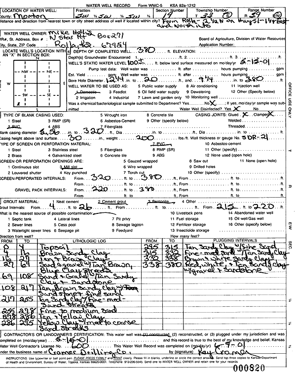
Specific Water Well Detail |
|
|
| Location Info | |||
| Owner: Hollis, Mike | Status: Constructed | ||
| Location: T33S, R39W, Sec. 19, SW SW SW | County: Morton | ||
| Directions: From Rolla: 2.5 mi N on Hwy 51, 1.13 mi NE | |||
| Latitude: 37.157079 | Longitude: -101.6083252 | Datum NAD 27 | |
| Latitude: 37.1571039 | Longitude: -101.6087639 | Datum NAD 83 | |
| Longitude and latitude calculated by Survey from township-range-section-quarter calls. Only good to within the quarter call accuracy. | |||
| View well on interactive map | |||
| General Info | ||
| Well Depth: 380 ft. | Elevation: ft. | |
| Static Water Level: 100 ft. | Est. Yield: gpm. | |
| Comp. Date: 15-May-2001 | Well Use: Domestic | |
| DWR Applic. #: | Other ID: | |
| Driller Info | ||
| Driller: Ray Cramer Drilling Co. | License #: 600 | |
| Scanned Form | View scan |
|
Chemical Sample Submitted?:
Water Well disinfected?: | ||
| Casing Info | ||
| Casing Type:
Casing Joints: |
Diam: in. to ft | |
| Casing height above land surface: in
Casing Weight: lbs/ft Wall thickness or gauge no.: | ||
| Screen and Perforation Info | ||
| Screen Type: | Screen Openings: | |
| Screen-perforated intervals | From: ft to ft | |
| Gravel pack intervals | From: ft to ft | |
| Grout Info | ||
| Grout used: | From: to ft | |
| Source of Possible Contamination | ||
| Source: | ||
| Direction from well: | Distance: ft | |
| Lithologic Log
(Log data entered by KGS.) | ||
| From: 0 ft. to 4 ft. | topsoil | |
| From: 4 ft. to 16 ft. | brown sandy clay | |
| From: 16 ft. to 27 ft. | tan and brown clay | |
| From: 27 ft. to 69 ft. | sand and gravel with tan, brown, blue clay streaks | |
| From: 69 ft. to 108 ft. | sand and gravel with tan sandy clay and sandstone | |
| From: 108 ft. to 217 ft. | tan, brown sandy clay with sandstone and fine sand | |
| From: 217 ft. to 255 ft. | tan sandy clay with fine-med sand streaks | |
| From: 255 ft. to 278 ft. | fine to medium sand | |
| From: 278 ft. to 286 ft. | tan and yellow clay | |
| From: 286 ft. to 295 ft. | yellow clay with med to coarse sand streaks | |
| From: 295 ft. to 315 ft. | tan sandy clay with fine sand | |
| From: 315 ft. to 332 ft. | fine-med sand with tan sandy clay | |
| From: 332 ft. to 338 ft. | brown and white sandy clay | |
| From: 338 ft. to 380 ft. | red, white, and tan sandy clay with gravel and sandstone | |