|
|
|
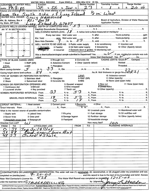
Specific Water Well Detail |
|
|
| Location Info | |||
| Owner: Hammond, Craig | Status: Constructed | ||
| Location: T1S, R20W, Sec. 23, SE SE SW | County: Phillips | ||
| Directions: From the S side of Long Island: .5 mi W | |||
| Latitude: 39.944941 | Longitude: -99.5436236 | Datum NAD 27 | |
| Latitude: 39.9449503 | Longitude: -99.5440073 | Datum NAD 83 | |
| Longitude and latitude calculated by Survey from township-range-section-quarter calls. Only good to within the quarter call accuracy. | |||
| View well on interactive map | |||
| General Info | ||
| Well Depth: 53 ft. | Elevation: ft. | |
| Static Water Level: 18 ft. | Est. Yield: gpm. | |
| Comp. Date: 20-Sep-2000 | Well Use: Domestic, Lawn and Garden | |
| DWR Applic. #: | Other ID: | |
| Driller Info | ||
| Driller: Leo J. Stalder Drilling | License #: 428 | |
| Scanned Form | View scan |
|
Chemical Sample Submitted?:
Water Well disinfected?: | ||
| Casing Info | ||
| Casing Type:
Casing Joints: |
Diam: in. to ft | |
| Casing height above land surface: in
Casing Weight: lbs/ft Wall thickness or gauge no.: | ||
| Screen and Perforation Info | ||
| Screen Type: | Screen Openings: | |
| Screen-perforated intervals | From: ft to ft | |
| Gravel pack intervals | From: ft to ft | |
| Grout Info | ||
| Grout used: | From: to ft | |
| Source of Possible Contamination | ||
| Source: | ||
| Direction from well: | Distance: ft | |
| Lithologic Log
(Log data entered by KGS.) | ||
| From: 0 ft. to 34 ft. | topsoil and clay | |
| From: 34 ft. to 48 ft. | sand, gravel, loose flint | |
| From: 48 ft. to 53 ft. | ochre and shale | |