|
|
|
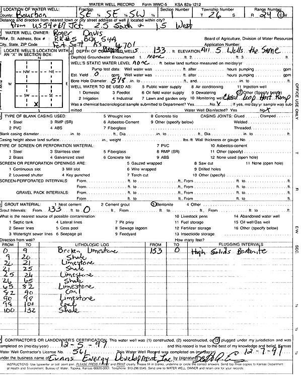
Specific Water Well Detail |
|
|
| Location Info | |||
| Owner: Davis, Roger | Status: Constructed | ||
| Location: T26S, R24E, Sec. 1, SE SE SW | County: Bourbon | ||
| Directions: from 54 and 69: 1.5 mi S, 1.5 mi W (five 133-foot bores) | |||
| Latitude: 37.8059955 | Longitude: -94.7337301 | Datum NAD 27 | |
| Latitude: 37.8060371 | Longitude: -94.7339709 | Datum NAD 83 | |
| Longitude and latitude calculated by Survey from township-range-section-quarter calls. Only good to within the quarter call accuracy. | |||
| View well on interactive map | |||
| General Info | ||
| Well Depth: 133 ft. | Elevation: ft. | |
| Static Water Level: ft. | Est. Yield: gpm. | |
| Comp. Date: 05-Dec-1997 | Well Use: Geothermal, Closed Loop, Vertical | |
| DWR Applic. #: | Other ID: | |
| Driller Info | ||
| Driller: Evans Energy Development, Inc. | License #: 561 | |
| Scanned Form | View scan |
|
Chemical Sample Submitted?:
Water Well disinfected?: | ||
| Casing Info | ||
| Casing Type:
Casing Joints: |
Diam: in. to ft | |
| Casing height above land surface: in
Casing Weight: lbs/ft Wall thickness or gauge no.: | ||
| Screen and Perforation Info | ||
| Screen Type: | Screen Openings: | |
| Screen-perforated intervals | From: ft to ft | |
| Gravel pack intervals | From: ft to ft | |
| Grout Info | ||
| Grout used: | From: to ft | |
| Source of Possible Contamination | ||
| Source: | ||
| Direction from well: | Distance: ft | |
| Lithologic Log
(Log data entered by KGS.) | ||
| From: 0 ft. to 9 ft. | broken limestone | |
| From: 9 ft. to 20 ft. | shale | |
| From: 20 ft. to 21 ft. | limestone | |
| From: 21 ft. to 25 ft. | shale | |
| From: 25 ft. to 26 ft. | limestone | |
| From: 26 ft. to 65 ft. | shale | |
| From: 65 ft. to 82 ft. | limestone | |
| From: 82 ft. to 90 ft. | coal | |
| From: 90 ft. to 98 ft. | limestone | |
| From: 98 ft. to 100 ft. | coal | |
| From: 100 ft. to 132 ft. | shale | |