|
|
|
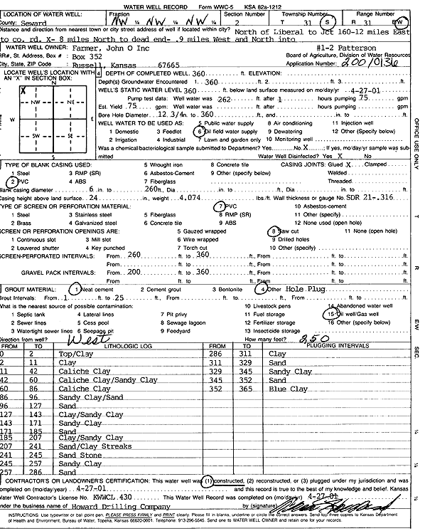
Specific Water Well Detail |
|
|
| Location Info | |||
| Owner: John O Farmer Inc | Status: Constructed | ||
| Location: T31S, R31W, Sec. 2, NW NW NW | County: Seward | ||
| Directions: from Liberal: N to Jct 160, 12 mi E to Co Rd X, 8 mi N to dead end, .9 mi W, N into | |||
| Latitude: 37.3867112 | Longitude: -100.6691548 | Datum NAD 27 | |
| Latitude: 37.3867337 | Longitude: -100.6695883 | Datum NAD 83 | |
| Longitude and latitude calculated by Survey from township-range-section-quarter calls. Only good to within the quarter call accuracy. | |||
| View well on interactive map | |||
| General Info | ||
| Well Depth: 360 ft. | Elevation: ft. | |
| Static Water Level: 360 ft. | Est. Yield: 75 gpm. | |
| Comp. Date: 27-Apr-2001 | Well Use: Oil Field Water Supply | |
| DWR Applic. #: 20010136 | Other ID: Paterson 1-2 | |
| Links | |
| No Wizard information available. | |
| View info from WIMAS Water Right Data base... | |
| Driller Info | ||
| Driller: Howard Drilling Company AG, LLC | License #: 430 | |
| Scanned Form | View scan |
|
Chemical Sample Submitted?:
Water Well disinfected?: | ||
| Casing Info | ||
| Casing Type:
Casing Joints: |
Diam: in. to ft | |
| Casing height above land surface: in
Casing Weight: lbs/ft Wall thickness or gauge no.: | ||
| Screen and Perforation Info | ||
| Screen Type: | Screen Openings: | |
| Screen-perforated intervals | From: ft to ft | |
| Gravel pack intervals | From: ft to ft | |
| Grout Info | ||
| Grout used: | From: to ft | |
| Source of Possible Contamination | ||
| Source: | ||
| Direction from well: | Distance: ft | |
| Lithologic Log
(Log data entered by KGS.) | ||
| From: 0 ft. to 2 ft. | top/clay | |
| From: 2 ft. to 11 ft. | clay | |
| From: 11 ft. to 42 ft. | caliche clay | |
| From: 42 ft. to 60 ft. | caliche clay/sandy clay | |
| From: 60 ft. to 86 ft. | caliche clay | |
| From: 86 ft. to 96 ft. | sandy clay/sand | |
| From: 96 ft. to 127 ft. | sand | |
| From: 127 ft. to 143 ft. | clay/sandy clay | |
| From: 143 ft. to 171 ft. | sandy clay | |
| From: 171 ft. to 185 ft. | sand | |
| From: 185 ft. to 207 ft. | clay/sandy clay | |
| From: 207 ft. to 241 ft. | sand/clay streaks | |
| From: 241 ft. to 245 ft. | sandstone | |
| From: 245 ft. to 257 ft. | sandy clay | |
| From: 257 ft. to 286 ft. | sand | |
| From: 286 ft. to 311 ft. | clay | |
| From: 311 ft. to 329 ft. | sand | |
| From: 329 ft. to 345 ft. | sandy clay | |
| From: 345 ft. to 352 ft. | sand | |
| From: 352 ft. to 365 ft. | blue clay | |